
Magnitude |
1.6 |
| Date & Time (UTC) | 2013-05-02 10:32:26.2 |
| Date & Time (Local) | 1392/2/12 15:02:26.2 |
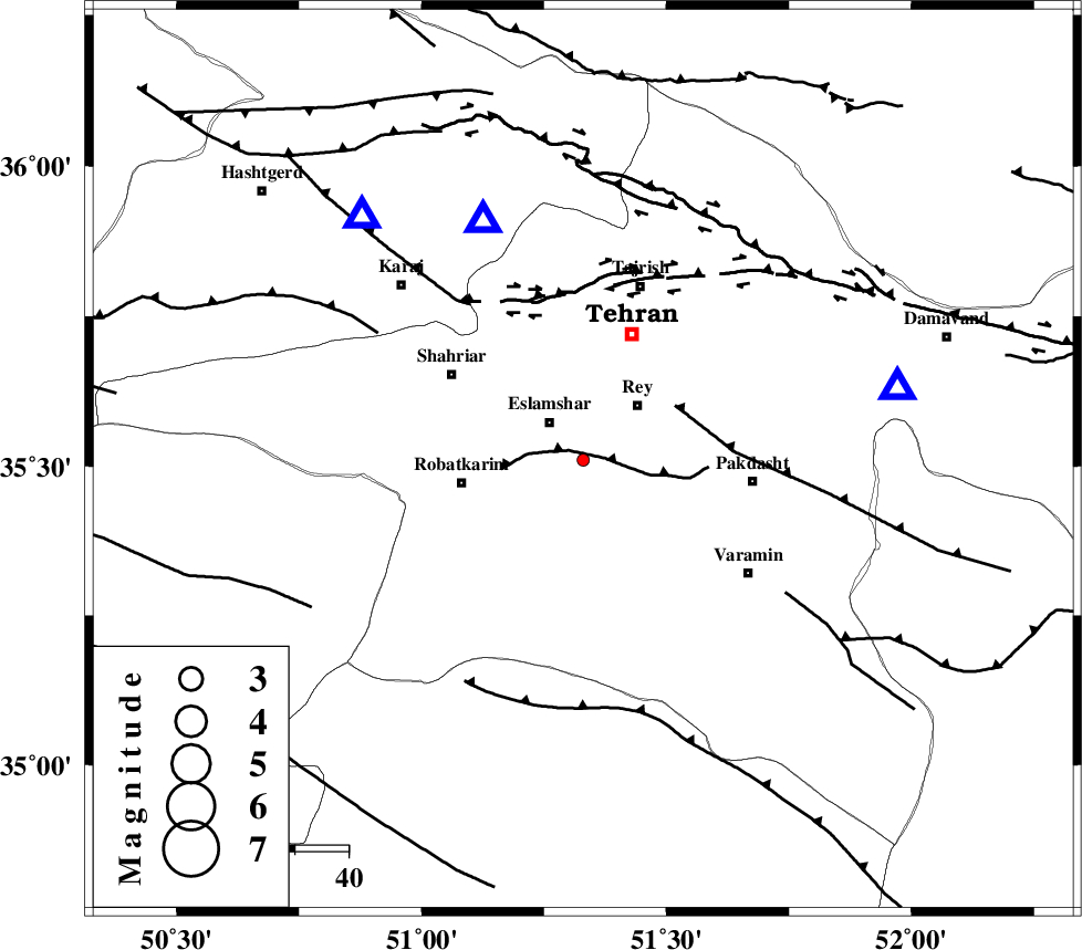
| Location | Lat:35.51 Lon: 51.33 |
| Region | Tehran Province, 9 km Eslamshahr |
Nearest Cities |
|
| 3 km of Kahrizak, Tehran Province | |
| 6 km of Deh abbas, Tehran Province | |
| 9 km of Eslamshahr, Tehran Province | |
| 13 km South of Firooz bahram, Tehran Province | |
| 14 km West of Rey, Tehran Province | |
| Depth | 42 km |
| Agency | |
Faults within 150 km: |
|
| KAHRIZAK_F (Length: 44 km) , Distance to epicenter: 3 km | |
| EYVANEKEY_F (Length: 74 km) , Distance to epicenter: 20 km | |
| N_TEHRAN_F4 (Length: 115 km) , Distance to epicenter: 29 km | |
| Number of Phases | 5 |
| RMS | 0.1 |
| Number of Stations | 3 |
| Error in Latitude | >3 km |
| Error in Longitude | 1.9 km |
| Error in Depth | 7.1 km |
Download waveform in seisan format
to download seisan software Click here
to access information about IIEES stations Click here
Amplitude | ||||||||
| UID | Agency | Station | Component | Amplitude | Period | Arrival Time | Proccessing Time | Signal Clip |
| 89054 | IIEES | DAMV | E | 46.9 | 0.38 | 2013-05-02 10:32:47 | 2013-05-03 01:51:00 | n |
| 89055 | IIEES | GHVR | N | 8.8 | 0.43 | 2013-05-02 10:33:07 | 2013-05-03 01:51:00 | n |
Phase | ||||||||||||
| Agency | Station | Component | Phase Type | Phase Quality | First Motion | Observed Arrival Time | Time Residual | Loc. Flag | Input Weight | Distance | Azimuth | |
| IIEES | CHTH | N | Pg | E | 2013-05-02 10:32:36 | 0.08 | y | 47.6 | 337 | |||
| IIEES | CHTH | N | Sg | E | 2013-05-02 10:32:44 | -0.05 | y | 47.6 | 337 | |||
| IIEES | DAMV | Z | Pg | E | 2013-05-02 10:32:38 | -0.08 | y | 59.4 | 77 | |||
| IIEES | DAMV | E | Sg | E | 2013-05-02 10:32:47 | 0.05 | y | 59.4 | 77 | |||
| IIEES | GHVR | Z | Pg | E | 2013-05-02 10:32:45 | 0 | y | 115 | 184 | |||