
Magnitude |
3.4 |
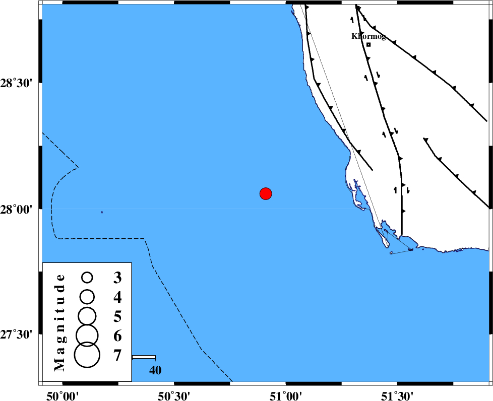
| Date & Time (UTC) | 2013-04-10 01:38:37.3 |
| Date & Time (Local) | 1392/1/21 06:08:37.3 |
| Location | Lat:28.06 Lon: 50.91 |
| Region | Persian Gulf |
Nearest Cities |
|
| 46 km South West of Ziyarat, Bushehr Province | |
| 55 km North West of Bardkhun, Bushehr Province | |
| 61 km South West of Abkesh, Bushehr Province | |
| 67 km South West of Kaki, Bushehr Province | |
| 68 km South West of Baduleh, Bushehr Province | |
| Depth | 26 km |
| Agency | |
Faults within 150 km: |
|
| ZFF2 (Length: 84 km) , Distance to epicenter: 43 km | |
| BORAZJAN_F (Length: 168 km) , Distance to epicenter: 60 km | |
| MFF3 (Length: 292 km) , Distance to epicenter: 74 km | |
| Number of Phases | 4 |
| RMS | 0.2 |
| Number of Stations | 4 |
| Error in Latitude | >999.9 km |
| Error in Longitude | 999.9 km |
| Error in Depth | 999.9 km |
Download waveform in seisan format
to download seisan software Click here
to access information about IIEES stations Click here
Amplitude | ||||||||
| UID | Agency | Station | Component | Amplitude | Period | Arrival Time | Proccessing Time | Signal Clip |
| 89083 | IIEES | AHRM | E | 829.4 | 0.45 | 2013-04-10 01:39:10 | 2013-05-01 04:08:00 | n |
| 89084 | IIEES | AHRM | N | 971.6 | 0.64 | 2013-04-10 01:39:14 | 2013-05-01 04:08:00 | n |
| 89085 | IIEES | GHIR | E | 566.4 | 0.38 | 2013-04-10 01:39:39 | 2013-05-01 04:08:00 | n |
Phase | ||||||||||||
| Agency | Station | Component | Phase Type | Phase Quality | First Motion | Observed Arrival Time | Time Residual | Loc. Flag | Input Weight | Distance | Azimuth | |
| IIEES | AHRM | Z | Pg | E | 2013-04-10 01:38:53 | -0.09 | y | 96.6 | 23 | |||
| IIEES | GHIR | Z | Pg | E | 2013-04-10 01:39:10 | 0.09 | y | 205 | 83 | |||
| IIEES | YZKH | Z | Pn | E | 2013-04-10 01:39:58 | 0.34 | y | 596 | 36 | |||
| IIEES | KRBR | Z | Pn | E | 2013-04-10 01:39:59 | -0.35 | y | 608 | 68 | |||