
Magnitude |
4.4 |
| Date & Time (UTC) | 2013-05-12 01:06:23.4 |
| Date & Time (Local) | 1392/2/22 05:36:23.4 |
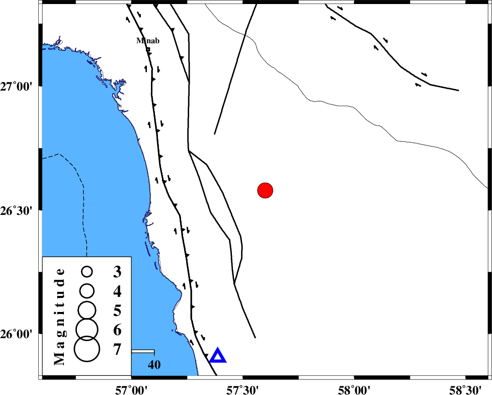
| Location | Lat:26.58 Lon: 57.6 |
| Region | Hormozgan Province, 93 km South-East of Manujan |
Nearest Cities |
|
| 8 km of Darpahn, Hormozgan Province | |
| 30 km West of Angahran, Hormozgan Province | |
| 33 km South East of Sanadrak, Hormozgan Province | |
| 45 km North East of Gonmardi, Hormozgan Province | |
| 50 km North East of Bandar-e sirk, Hormozgan Province | |
| Depth | 15 km |
| Agency | |
Faults within 150 km: |
|
| ZENDAN_MINAB_F_Z2 (Length: 63 km) , Distance to epicenter: 19 km | |
| ZENDAN_MINAB_F_Z1 (Length: 183 km) , Distance to epicenter: 26 km | |
| SABZEVARAN_F (Length: 190 km) , Distance to epicenter: 34 km | |
| Number of Phases | 6 |
| RMS | 0.3 |
| Number of Stations | 6 |
| Error in Latitude | >7.6 km |
| Error in Longitude | 5.2 km |
| Error in Depth | 8.6 km |
Download waveform in seisan format
to download seisan software Click here
to access information about IIEES stations Click here
Amplitude | ||||||||
| UID | Agency | Station | Component | Amplitude | Period | Arrival Time | Proccessing Time | Signal Clip |
| 89206 | IIEES | AHRM | N | 112.7 | 0.6 | 2013-05-12 01:09:12 | 2013-05-12 02:40:00 | n |
Phase | ||||||||||||
| Agency | Station | Component | Phase Type | Phase Quality | First Motion | Observed Arrival Time | Time Residual | Loc. Flag | Input Weight | Distance | Azimuth | |
| IIEES | BNDS | Z | Pg | E | 2013-05-12 01:06:50 | -0.42 | y | 169 | 303 | |||
| IIEES | CHBR | Z | Pn | E | 2013-05-12 01:07:09 | -0.15 | y | 308 | 110 | |||
| IIEES | ZHSF | Z | P | E | 2013-05-12 01:07:28 | 0.25 | y | 458 | 42 | |||
| IIEES | GHIR | Z | Pn | E | 2013-05-12 01:07:33 | 0.63 | y | 494 | 294 | |||
| IIEES | BSRN | Z | P | E | 2013-05-12 01:07:47 | -0.14 | y | 615 | 14 | |||
| IIEES | AHRM | Z | Pn | E | 2013-05-12 01:07:54 | 0.07 | y | 671 | 294 | |||