
Magnitude |
2.6 |
| Date & Time (UTC) | 2013-05-12 17:47:43.5 |
| Date & Time (Local) | 1392/2/22 22:17:43.5 |
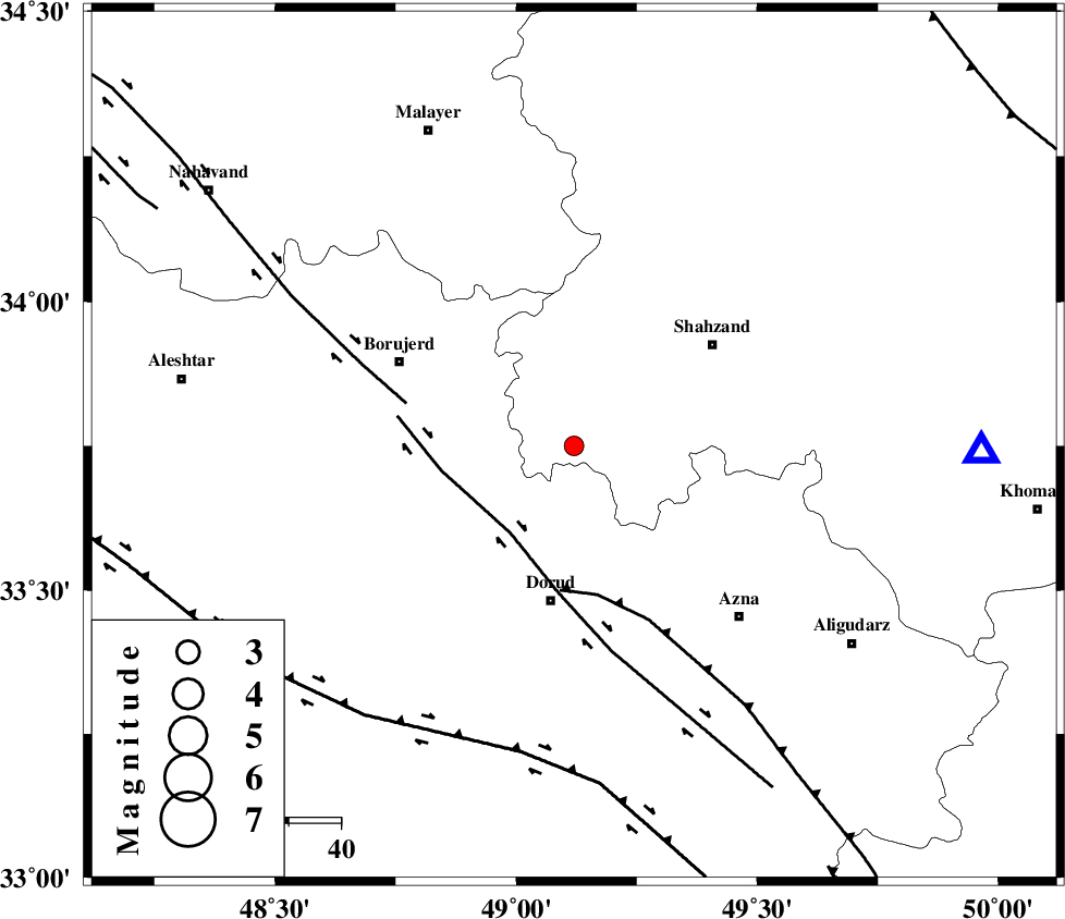
| Location | Lat:33.75 Lon: 49.12 |
| Region | Markazi Province, 31 km North of Dorud |
Nearest Cities |
|
| 6 km of Hashian, Markazi Province | |
| 11 km West of Hendudar, Markazi Province | |
| 19 km South of Dehkaeed, Markazi Province | |
| 22 km North East of Kagheh, Lorestan Province | |
| 23 km North of Zhan, Lorestan Province | |
| Depth | 17 km |
| Agency | |
Faults within 150 km: |
|
| DORUD (Length: 100 km) , Distance to epicenter: 21 km | |
| MAIN_ZAGROS_R_F (Length: 1106 km) , Distance to epicenter: 28 km | |
| NAHAVAND_F (Length: 102 km) , Distance to epicenter: 33 km | |
| Number of Phases | 6 |
| RMS | 0.1 |
| Number of Stations | 4 |
| Error in Latitude | >2.5 km |
| Error in Longitude | 1.4 km |
| Error in Depth | 3.4 km |
Download waveform in seisan format
to download seisan software Click here
to access information about IIEES stations Click here
Amplitude | ||||||||
| UID | Agency | Station | Component | Amplitude | Period | Arrival Time | Proccessing Time | Signal Clip |
| 89237 | IIEES | ASAO | E | 158.5 | 0.56 | 2013-05-12 17:48:23 | 2013-05-12 08:14:00 | n |
| 89238 | IIEES | GHVR | N | 47.8 | 0.84 | 2013-05-12 17:48:48 | 2013-05-12 08:14:00 | n |
| 89239 | IIEES | GHVR | E | 41.4 | 0.52 | 2013-05-12 17:48:58 | 2013-05-12 08:14:00 | n |
Phase | ||||||||||||
| Agency | Station | Component | Phase Type | Phase Quality | First Motion | Observed Arrival Time | Time Residual | Loc. Flag | Input Weight | Distance | Azimuth | |
| IIEES | KHMZ | Z | Pg | E | 2013-05-12 17:47:57 | 0.08 | y | 78.4 | 91 | |||
| IIEES | ASAO | Z | Pg | E | 2013-05-12 17:48:03 | -0.19 | y | 121 | 43 | |||
| IIEES | ASAO | E | Sg | E | 2013-05-12 17:48:19 | 0.09 | y | 121 | 43 | |||
| IIEES | GHVR | Z | Pn | E | 2013-05-12 17:48:17 | -0.03 | y | 212 | 67 | |||
| IIEES | SNGE | Z | Pn | E | 2013-05-12 17:48:18 | 0.04 | y | 220 | 313 | |||
| IIEES | SNGE | N | Sg | E | 2013-05-12 17:48:46 | 0.01 | y | 220 | 313 | |||