
Magnitude |
4.5 |
| Date & Time (UTC) | 2013-05-12 22:40:33.4 |
| Date & Time (Local) | 1392/2/23 03:10:33.4 |
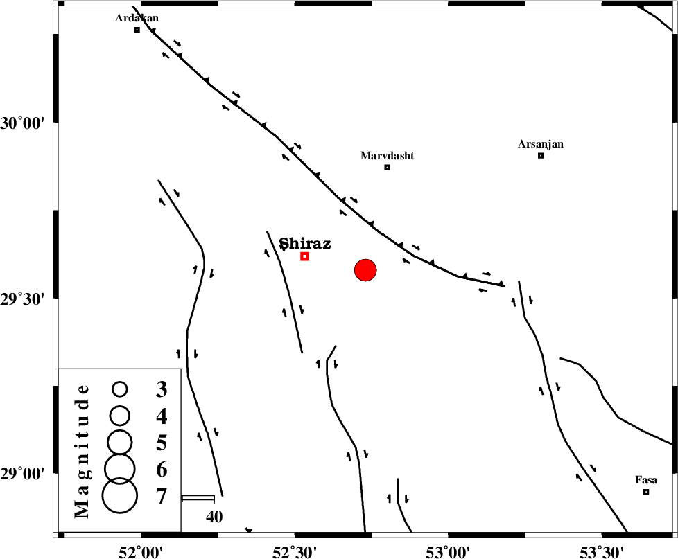
| Location | Lat:29.58 Lon: 52.73 |
| Region | Fars Province, 20 km East of Shiraz |
Nearest Cities |
|
| 15 km North East of Soltanabad, Fars Province | |
| 20 km East of Shiraz, Fars Province | |
| 20 km North West of Darian, Fars Province | |
| 22 km South of Zarghan, Fars Province | |
| 24 km South of Lapuee, Fars Province | |
| Depth | 14 km |
| Agency | |
Faults within 150 km: |
|
| HZF3 (Length: 197 km) , Distance to epicenter: 13 km | |
| SABZ_PUSHAN_F_Z3 (Length: 37 km) , Distance to epicenter: 25 km | |
| SABZ_PUSHAN_F_Z1 (Length: 69 km) , Distance to epicenter: 26 km | |
| Number of Phases | 6 |
| RMS | 0.1 |
| Number of Stations | 4 |
| Error in Latitude | >1 km |
| Error in Longitude | 2.2 km |
| Error in Depth | 3.8 km |
Download waveform in seisan format
to download seisan software Click here
to access information about IIEES stations Click here
Amplitude | ||||||||
| UID | Agency | Station | Component | Amplitude | Period | Arrival Time | Proccessing Time | Signal Clip |
| 89246 | IIEES | GHIR | N | 4751.8 | 0.44 | 2013-05-12 22:41:20 | 2013-05-13 12:05:00 | n |
| 89247 | IIEES | AHRM | N | 9650.1 | 0.92 | 2013-05-12 22:41:22 | 2013-05-13 12:05:00 | n |
Phase | ||||||||||||
| Agency | Station | Component | Phase Type | Phase Quality | First Motion | Observed Arrival Time | Time Residual | Loc. Flag | Input Weight | Distance | Azimuth | |
| IIEES | GHIR | Z | Pg | E | 2013-05-12 22:40:57 | -0.11 | y | 146 | 170 | |||
| IIEES | GHIR | N | Sg | E | 2013-05-12 22:41:15 | 0.08 | y | 146 | 170 | |||
| IIEES | AHRM | Z | Pg | E | 2013-05-12 22:40:59 | 0.01 | y | 161 | 241 | |||
| IIEES | YZKH | Z | Pn | E | 2013-05-12 22:41:25 | 0.1 | y | 358 | 29 | |||
| IIEES | YZKH | E | Sg | E | 2013-05-12 22:42:13 | -0.02 | y | 358 | 29 | |||
| IIEES | TABS | Z | Pn | E | 2013-05-12 22:41:57 | -0.07 | y | 614 | 42 | |||