
Magnitude |
3.2 |
| Date & Time (UTC) | 2013-05-13 20:36:59.5 |
| Date & Time (Local) | 1392/2/24 01:06:59.5 |
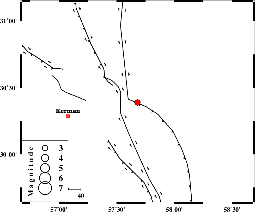
| Location | Lat:30.39 Lon: 57.68 |
| Region | Kerman Province, 59 km East of Kerman |
Nearest Cities |
|
| 4 km of Shahdad, Kerman Province | |
| 17 km West of Estehkam, Kerman Province | |
| 24 km North East of Sirch, Kerman Province | |
| 32 km North of Jushan, Kerman Province | |
| 41 km South East of Dehlulu, Kerman Province | |
| Depth | 15 km |
| Agency | |
Faults within 150 km: |
|
| SHAHDAD_F (Length: 108 km) , Distance to epicenter: 8 km | |
| NAYBAND_F (Length: 258 km) , Distance to epicenter: 8 km | |
| GOLBAF_SIRCH_F (Length: 114 km) , Distance to epicenter: 14 km | |
| Number of Phases | 4 |
| RMS | 0.2 |
| Number of Stations | 4 |
| Error in Latitude | >5.1 km |
| Error in Longitude | 2 km |
| Error in Depth | 0 km |
Download waveform in seisan format
to download seisan software Click here
to access information about IIEES stations Click here
Amplitude | ||||||||
| UID | Agency | Station | Component | Amplitude | Period | Arrival Time | Proccessing Time | Signal Clip |
| 89263 | IIEES | BSRN | E | 172.7 | 0.41 | 2013-05-13 20:38:03 | 2013-05-13 10:08:00 | n |
| 89264 | IIEES | BSRN | N | 159 | 0.2 | 2013-05-13 20:38:04 | 2013-05-13 10:08:00 | n |
Phase | ||||||||||||
| Agency | Station | Component | Phase Type | Phase Quality | First Motion | Observed Arrival Time | Time Residual | Loc. Flag | Input Weight | Distance | Azimuth | |
| IIEES | BSRN | Z | Pn | E | 2013-05-13 20:37:35 | 0.22 | y | 223 | 38 | |||
| IIEES | ZHSF | Z | Pn | E | 2013-05-13 20:37:45 | -0.08 | y | 310 | 105 | |||
| IIEES | TABS | Z | Pn | E | 2013-05-13 20:37:52 | -0.33 | y | 366 | 352 | |||
| IIEES | YZKH | Z | Pn | E | 2013-05-13 20:37:53 | 0.16 | y | 369 | 308 | |||