
Magnitude |
2.8 |
| Date & Time (UTC) | 2013-05-16 23:29:51.3 |
| Date & Time (Local) | 1392/2/27 03:59:51.3 |
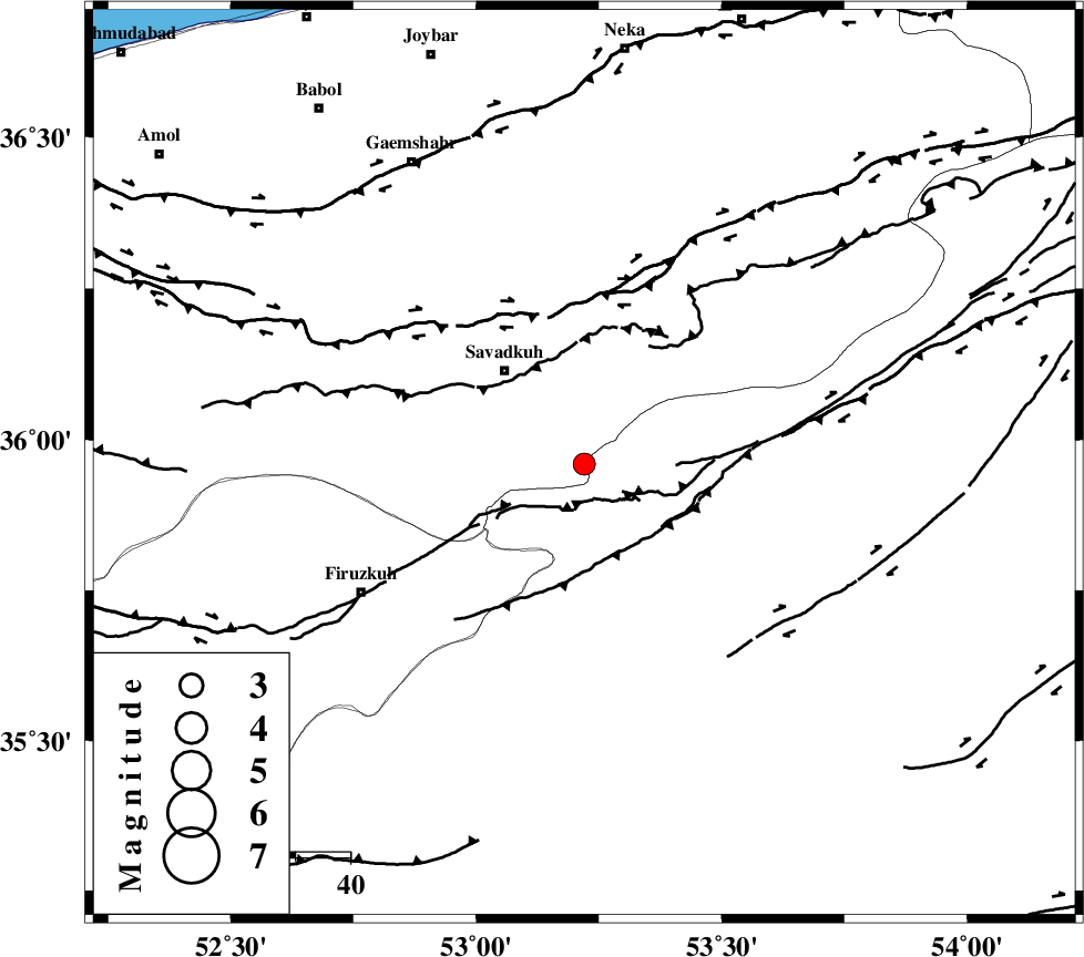
| Location | Lat:35.96 Lon: 53.22 |
| Region | Mazandaran Province, 22 km South-East of Pol-E-Sefid |
Nearest Cities |
|
| 9 km North of Chashem, Semnan Province | |
| 12 km South of Sangdeh, Mazandaran Province | |
| 21 km South East of Shurmast-e peyrudbar, Mazandaran Province | |
| 23 km South East of Pol-E-Sefid, Mazandaran Province | |
| 24 km North West of Shahmirzad, Semnan Province | |
| Depth | 14 km |
| Agency | |
Faults within 150 km: |
|
| N_ALBORZ_F (Length: 360 km) , Distance to epicenter: 28 km | |
| ATARI_F (Length: 185 km) , Distance to epicenter: 32 km | |
| DAMGHAN_F (Length: 95 km) , Distance to epicenter: 59 km | |
| Number of Phases | 6 |
| RMS | 0.1 |
| Number of Stations | 6 |
| Error in Latitude | >4 km |
| Error in Longitude | 2.6 km |
| Error in Depth | 4.2 km |
Download waveform in seisan format
to download seisan software Click here
to access information about IIEES stations Click here
Amplitude | ||||||||
| UID | Agency | Station | Component | Amplitude | Period | Arrival Time | Proccessing Time | Signal Clip |
| 89300 | IIEES | DAMV | E | 197 | 0.2 | 2013-05-16 23:30:29 | 2013-05-17 01:24:00 | n |
| 89301 | IIEES | GHVR | E | 86.9 | 0.48 | 2013-05-16 23:31:05 | 2013-05-17 01:24:00 | n |
| 89302 | IIEES | GHVR | N | 58.9 | 0.4 | 2013-05-16 23:31:07 | 2013-05-17 01:24:00 | n |
Phase | ||||||||||||
| Agency | Station | Component | Phase Type | Phase Quality | First Motion | Observed Arrival Time | Time Residual | Loc. Flag | Input Weight | Distance | Azimuth | |
| IIEES | DAMV | Z | Pg | E | 2013-05-16 23:30:11 | -0.17 | y | 119 | 252 | |||
| IIEES | CHTH | Z | Pg | E | 2013-05-16 23:30:22 | 0.02 | y | 189 | 269 | |||
| IIEES | THKV | Z | Pn | E | 2013-05-16 23:30:25 | 0.08 | y | 211 | 269 | |||
| IIEES | GHVR | Z | Pn | E | 2013-05-16 23:30:29 | 0.1 | y | 244 | 228 | |||
| IIEES | SHRO | Z | Pn | E | 2013-05-16 23:30:30 | -0.03 | y | 252 | 88 | |||
| IIEES | MRVT | Z | Pn | E | 2013-05-16 23:30:38 | 0 | y | 318 | 53 | |||