
Magnitude |
2.3 |
| Date & Time (UTC) | 2013-05-16 15:37:51.8 |
| Date & Time (Local) | 1392/2/26 20:07:51.8 |
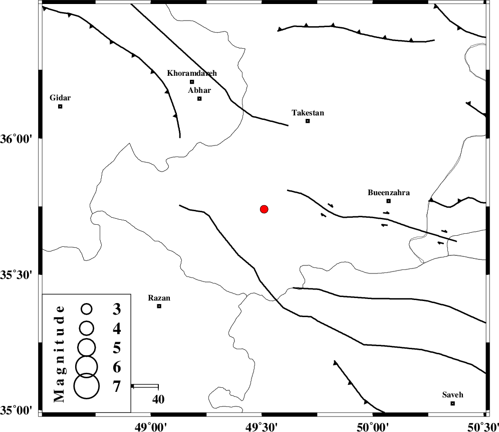
| Location | Lat:35.74 Lon: 49.51 |
| Region | Ghazvin Province, 40 km South-West of Takestan |
Nearest Cities |
|
| 14 km North of Kolanjin, Ghazvin Province | |
| 15 km East of Hoseynabad, Ghazvin Province | |
| 20 km East of Ab-e garm, Ghazvin Province | |
| 21 km South of Nahavand, Ghazvin Province | |
| 21 km West of Danesfahan, Ghazvin Province | |
| Depth | 46 km |
| Agency | |
Faults within 150 km: |
|
| IPAK_F (Length: 80 km) , Distance to epicenter: 12 km | |
| KUSHK_E_NOSRAT_F (Length: 230 km) , Distance to epicenter: 21 km | |
| S_PARANDAK_F (Length: 116 km) , Distance to epicenter: 34 km | |
| Number of Phases | 5 |
| RMS | 0.1 |
| Number of Stations | 5 |
| Error in Latitude | >6.1 km |
| Error in Longitude | 8 km |
| Error in Depth | 4.2 km |
Download waveform in seisan format
to download seisan software Click here
to access information about IIEES stations Click here
Amplitude | ||||||||
| UID | Agency | Station | Component | Amplitude | Period | Arrival Time | Proccessing Time | Signal Clip |
| 89305 | IIEES | GHVR | E | 22.4 | 0.4 | 2013-05-16 15:38:52 | 2013-05-17 08:25:00 | n |
| 89306 | IIEES | DAMV | E | 20.6 | 0.64 | 2013-05-16 15:38:51 | 2013-05-17 08:25:00 | n |
Phase | ||||||||||||
| Agency | Station | Component | Phase Type | Phase Quality | First Motion | Observed Arrival Time | Time Residual | Loc. Flag | Input Weight | Distance | Azimuth | |
| IIEES | THKV | Z | Pg | E | 2013-05-16 15:38:13 | 0.13 | y | 125 | 81 | |||
| IIEES | THKV | E | Sg | E | 2013-05-16 15:38:28 | -0.21 | y | 125 | 81 | |||
| IIEES | ASAO | Z | Pg | E | 2013-05-16 15:38:15 | 0.07 | y | 141 | 160 | |||
| IIEES | CHTH | Z | Pg | E | 2013-05-16 15:38:16 | 0.13 | y | 147 | 82 | |||
| IIEES | GHVR | Z | Pn | E | 2013-05-16 15:38:22 | y | 211 | 131 | ||||