
Magnitude |
3.1 |
| Date & Time (UTC) | 2013-05-17 19:35:15.8 |
| Date & Time (Local) | 1392/2/28 00:05:15.8 |
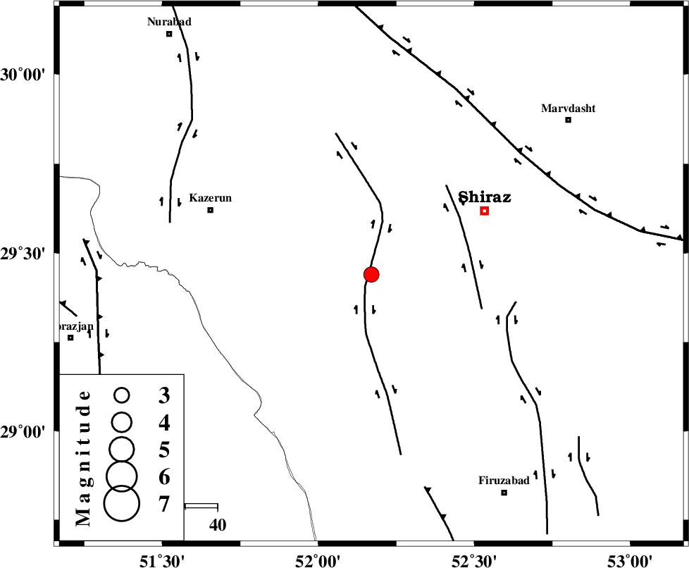
| Location | Lat:29.44 Lon: 52.17 |
| Region | Fars Province, 40 km South-West of Shiraz |
Nearest Cities |
|
| 6 km of Richi, Fars Province | |
| 26 km South of Khanehzanian, Fars Province | |
| 28 km North East of Baladeh, Fars Province | |
| 29 km North East of Jareh, Fars Province | |
| 33 km North East of Dadin-e olia, Fars Province | |
| Depth | 15 km |
| Agency | |
Faults within 150 km: |
|
| KAREBASS_F (Length: 98 km) , Distance to epicenter: 4 km | |
| SABZ_PUSHAN_F_Z3 (Length: 37 km) , Distance to epicenter: 31 km | |
| SABZ_PUSHAN_F_Z1 (Length: 69 km) , Distance to epicenter: 44 km | |
| Number of Phases | 6 |
| RMS | 0.1 |
| Number of Stations | 4 |
| Error in Latitude | >3.4 km |
| Error in Longitude | 1.4 km |
| Error in Depth | 8.8 km |
Download waveform in seisan format
to download seisan software Click here
to access information about IIEES stations Click here
Amplitude | ||||||||
| UID | Agency | Station | Component | Amplitude | Period | Arrival Time | Proccessing Time | Signal Clip |
| 89316 | IIEES | AHRM | E | 569 | 0.28 | 2013-05-17 19:35:50 | 2013-05-17 10:03:00 | n |
| 89317 | IIEES | GHIR | E | 282.3 | 0.48 | 2013-05-17 19:36:03 | 2013-05-17 10:03:00 | n |
| 89318 | IIEES | GHIR | N | 302.6 | 0.44 | 2013-05-17 19:36:04 | 2013-05-17 10:03:00 | n |
| 89319 | IIEES | KRBR | N | 20.9 | 0.4 | 2013-05-17 19:37:12 | 2013-05-17 10:03:00 | n |
| 89320 | IIEES | KRBR | E | 27.7 | 0.84 | 2013-05-17 19:37:29 | 2013-05-17 10:03:00 | n |
Phase | ||||||||||||
| Agency | Station | Component | Phase Type | Phase Quality | First Motion | Observed Arrival Time | Time Residual | Loc. Flag | Input Weight | Distance | Azimuth | |
| IIEES | AHRM | Z | Pg | E | 2013-05-17 19:35:33 | -0.09 | y | 106 | 233 | |||
| IIEES | AHRM | E | Sg | E | 2013-05-17 19:35:46 | 0.05 | y | 106 | 233 | |||
| IIEES | GHIR | Z | Pg | E | 2013-05-17 19:35:41 | 0.07 | y | 151 | 148 | |||
| IIEES | GHIR | E | Sg | E | 2013-05-17 19:35:59 | -0.03 | y | 151 | 148 | |||
| IIEES | YZKH | Z | Pn | E | 2013-05-17 19:36:13 | 0.03 | y | 401 | 35 | |||
| IIEES | KRBR | Z | Pn | E | 2013-05-17 19:36:19 | -0.04 | y | 448 | 81 | |||