
Magnitude |
2.6 |
| Date & Time (UTC) | 2013-05-17 18:39:38.3 |
| Date & Time (Local) | 1392/2/27 23:09:38.3 |
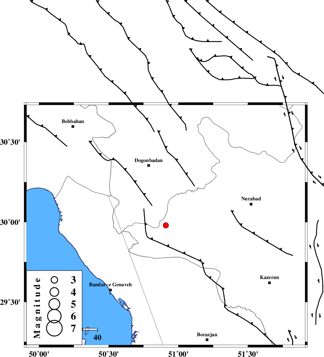
| Location | Lat:29.98 Lon: 50.91 |
| Region | Fars Province, 44 km South-East of Dogonbadan |
Nearest Cities |
|
| 30 km West of Babamonir, Fars Province | |
| 43 km South East of Dogonbadan, Kohkiluieh va boyerahmad Province | |
| 47 km North East of Mohammad salehi, Bushehr Province | |
| 49 km South West of Basht, Kohkiluieh va boyerahmad Province | |
| 50 km North East of Chehar rustaee, Bushehr Province | |
| Depth | 18 km |
| Agency | |
Faults within 150 km: |
|
| ZFF3 (Length: 125 km) , Distance to epicenter: 33 km | |
| MISHAN_F (Length: 76 km) , Distance to epicenter: 38 km | |
| RAG_E_SEFID_F (Length: 84 km) , Distance to epicenter: 55 km | |
| Number of Phases | 5 |
| RMS | 0 |
| Number of Stations | 5 |
| Error in Latitude | >5.5 km |
| Error in Longitude | 5.5 km |
| Error in Depth | 15.2 km |
Download waveform in seisan format
to download seisan software Click here
to access information about IIEES stations Click here
Amplitude | ||||||||
| UID | Agency | Station | Component | Amplitude | Period | Arrival Time | Proccessing Time | Signal Clip |
| 89322 | IIEES | GHIR | E | 28.2 | 0.84 | 2013-05-17 18:41:15 | 2013-05-18 03:39:00 | n |
Phase | ||||||||||||
| Agency | Station | Component | Phase Type | Phase Quality | First Motion | Observed Arrival Time | Time Residual | Loc. Flag | Input Weight | Distance | Azimuth | |
| IIEES | AHRM | Z | Pg | E | 2013-05-17 18:39:59 | 0.02 | y | 129 | 163 | |||
| IIEES | AHRM | N | Sg | E | 2013-05-17 18:40:15 | -0.01 | y | 129 | 163 | |||
| IIEES | KHMZ | Z | Pn | E | 2013-05-17 18:40:38 | 0.05 | y | 427 | 348 | |||
| IIEES | YZKH | Z | Pn | E | 2013-05-17 18:40:40 | 0.01 | y | 441 | 52 | |||
| IIEES | ASAO | Z | Pn | E | 2013-05-17 18:40:49 | -0.06 | y | 514 | 351 | |||