
Magnitude |
1.7 |
| Date & Time (UTC) | 2013-05-21 00:08:52.0 |
| Date & Time (Local) | 1392/2/31 04:38:52.0 |
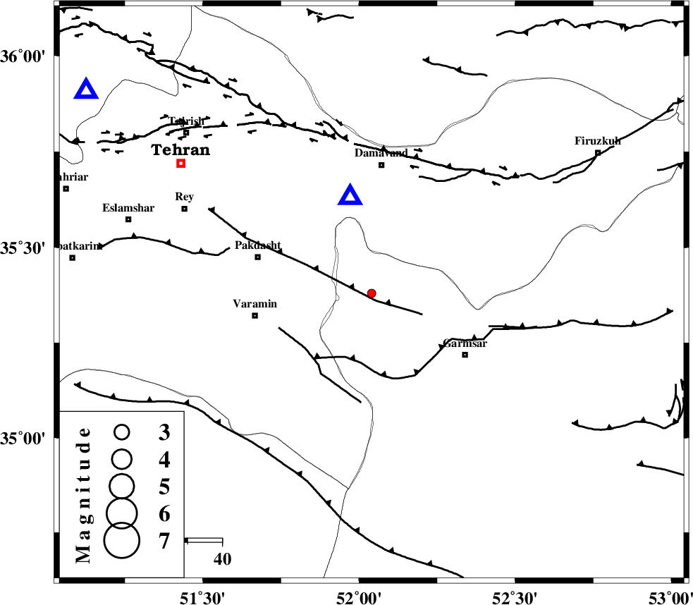
| Location | Lat:35.38 Lon: 52.04 |
| Region | Semnan Province, 38 km South of Damavand |
Nearest Cities |
|
| 5 km North of Evanekay, Semnan Province | |
| 11 km North of Cheshmeh nadi, Semnan Province | |
| 17 km North East of Shorqazi, Semnan Province | |
| 21 km South West of Kilan, Tehran Province | |
| 26 km North East of Khalilabad, Tehran Province | |
| Depth | 27 km |
| Agency | |
Faults within 150 km: |
|
| EYVANEKEY_F (Length: 74 km) , Distance to epicenter: 3 km | |
| GARMSAR_F (Length: 77 km) , Distance to epicenter: 20 km | |
| PISHAV_F (Length: 34 km) , Distance to epicenter: 25 km | |
| Number of Phases | 5 |
| RMS | 0.3 |
| Number of Stations | 5 |
| Error in Latitude | >4.8 km |
| Error in Longitude | 7.1 km |
| Error in Depth | 8 km |
Download waveform in seisan format
to download seisan software Click here
to access information about IIEES stations Click here
Amplitude | ||||||||
| UID | Agency | Station | Component | Amplitude | Period | Arrival Time | Proccessing Time | Signal Clip |
| 89380 | IIEES | GHVR | E | 11.8 | 0.2 | 2013-05-21 00:09:32 | 2013-05-21 03:58:00 | n |
| 89381 | IIEES | GHVR | N | 12.1 | 0.17 | 2013-05-21 00:09:32 | 2013-05-21 03:58:00 | n |
| 89382 | IIEES | ASAO | E | 9.4 | 0.44 | 2013-05-21 00:09:57 | 2013-05-21 03:58:00 | n |
Phase | ||||||||||||
| Agency | Station | Component | Phase Type | Phase Quality | First Motion | Observed Arrival Time | Time Residual | Loc. Flag | Input Weight | Distance | Azimuth | |
| IIEES | DAMV | Z | Pg | E | 2013-05-21 00:08:58 | 0.06 | y | 29 | 347 | |||
| IIEES | CHTH | N | Sg | E | 2013-05-21 00:09:21 | -0.44 | y | 102 | 306 | |||
| IIEES | THKV | E | Sg | E | 2013-05-21 00:09:27 | 0.42 | y | 121 | 300 | |||
| IIEES | GHVR | Z | Pg | E | 2013-05-21 00:09:12 | -0.05 | y | 123 | 216 | |||
| IIEES | ASAO | Z | Pn | E | 2013-05-21 00:09:24 | 0.01 | y | 206 | 244 | |||