
Magnitude |
3.3 |
| Date & Time (UTC) | 2013-05-21 05:30:25.4 |
| Date & Time (Local) | 1392/2/31 10:00:25.4 |
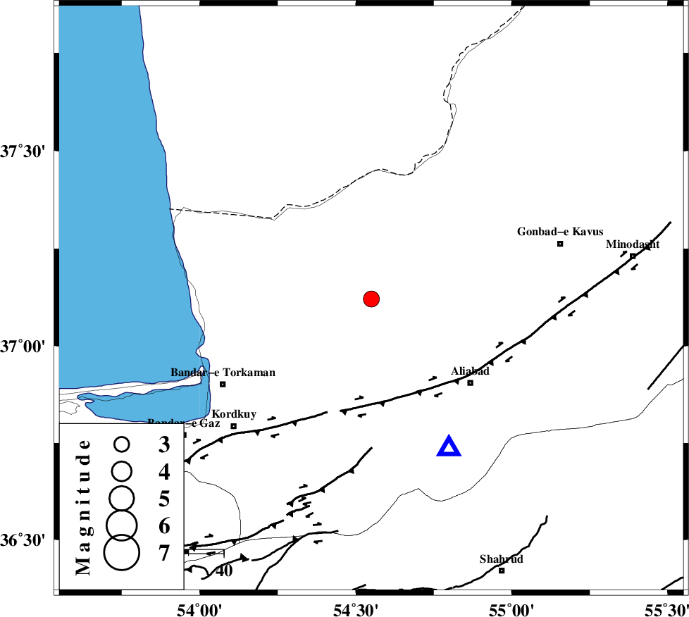
| Location | Lat:37.12 Lon: 54.55 |
| Region | Golestan Province, 14 km North of Aq Qaleh |
Nearest Cities |
|
| 13 km North of Qanqarmeh, Golestan Province | |
| 15 km North of Aq Qaleh, Golestan Province | |
| 16 km North of Nodeh malek, Golestan Province | |
| 17 km North West of Gariduji, Golestan Province | |
| 31 km North of Jalin olia, Golestan Province | |
| Depth | 18 km |
| Agency | |
Faults within 150 km: |
|
| KHAZAR_F (Length: 523 km) , Distance to epicenter: 30 km | |
| N_ALBORZ_F (Length: 360 km) , Distance to epicenter: 58 km | |
| SHAVAR_F (Length: 87 km) , Distance to epicenter: 63 km | |
| Number of Phases | 8 |
| RMS | 0.1 |
| Number of Stations | 7 |
| Error in Latitude | >2.1 km |
| Error in Longitude | 2.5 km |
| Error in Depth | 4.8 km |
Download waveform in seisan format
to download seisan software Click here
to access information about IIEES stations Click here
Amplitude | ||||||||
| UID | Agency | Station | Component | Amplitude | Period | Arrival Time | Proccessing Time | Signal Clip |
| 89383 | IIEES | MRVT | E | 454.6 | 0.17 | 2013-05-21 05:31:13 | 2013-05-21 07:21:00 | n |
Phase | ||||||||||||
| Agency | Station | Component | Phase Type | Phase Quality | First Motion | Observed Arrival Time | Time Residual | Loc. Flag | Input Weight | Distance | Azimuth | |
| IIEES | MRVT | Z | Pg | E | 2013-05-21 05:30:50 | -0.04 | y | 149 | 66 | |||
| IIEES | MRVT | N | Sg | E | 2013-05-21 05:31:08 | 0 | y | 149 | 66 | |||
| IIEES | SHRO | Z | Pg | E | 2013-05-21 05:30:55 | 0.06 | y | 180 | 133 | |||
| IIEES | DAMV | Z | Pn | E | 2013-05-21 05:31:08 | -0.02 | y | 284 | 235 | |||
| IIEES | CHTH | Z | Pn | E | 2013-05-21 05:31:14 | 0.09 | y | 334 | 247 | |||
| IIEES | TABS | Z | Pn | E | 2013-05-21 05:31:28 | 0.14 | y | 450 | 148 | |||
| IIEES | YZKH | Z | Pn | E | 2013-05-21 05:31:37 | -0.21 | y | 524 | 180 | |||
| IIEES | BSRN | Z | P | E | 2013-05-21 05:32:00 | -0.14 | y | 709 | 142 | |||