
Magnitude |
1.9 |
| Date & Time (UTC) | 2013-05-24 01:59:52.5 |
| Date & Time (Local) | 1392/3/3 06:29:52.5 |
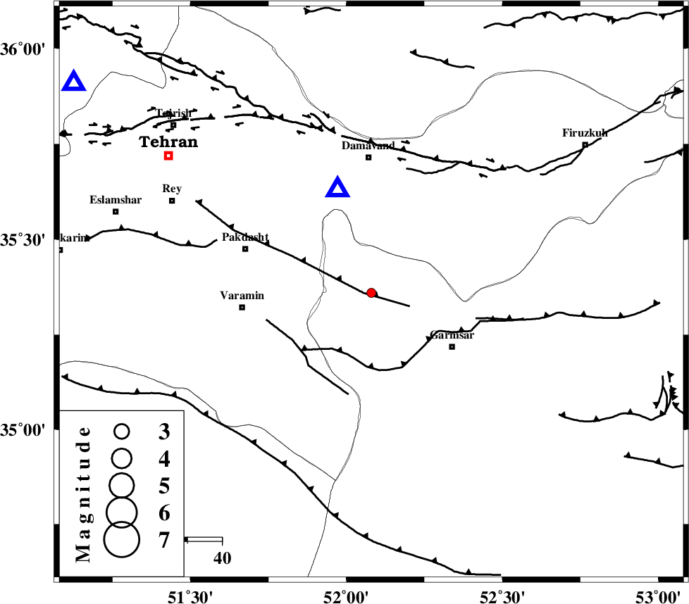
| Location | Lat:35.36 Lon: 52.08 |
| Region | Semnan Province, 39 km South of Damavand |
Nearest Cities |
|
| 3 km North of Evanekay, Semnan Province | |
| 11 km North of Cheshmeh nadi, Semnan Province | |
| 19 km North East of Shorqazi, Semnan Province | |
| 22 km South of Kilan, Tehran Province | |
| 28 km North West of Garmsar, Semnan Province | |
| Depth | 24 km |
| Agency | |
Faults within 150 km: |
|
| EYVANEKEY_F (Length: 74 km) , Distance to epicenter: 2 km | |
| GARMSAR_F (Length: 77 km) , Distance to epicenter: 19 km | |
| PISHAV_F (Length: 34 km) , Distance to epicenter: 27 km | |
| Number of Phases | 5 |
| RMS | 0.1 |
| Number of Stations | 4 |
| Error in Latitude | >2.9 km |
| Error in Longitude | 6.8 km |
| Error in Depth | 4.6 km |
Download waveform in seisan format
to download seisan software Click here
to access information about IIEES stations Click here
Amplitude | ||||||||
| UID | Agency | Station | Component | Amplitude | Period | Arrival Time | Proccessing Time | Signal Clip |
| 89416 | IIEES | THKV | E | 22.1 | 0.2 | 2013-05-24 02:00:30 | 2013-05-24 03:46:00 | n |
| 89417 | IIEES | ASAO | E | 10.7 | 0.32 | 2013-05-24 02:00:58 | 2013-05-24 03:46:00 | n |
Phase | ||||||||||||
| Agency | Station | Component | Phase Type | Phase Quality | First Motion | Observed Arrival Time | Time Residual | Loc. Flag | Input Weight | Distance | Azimuth | |
| IIEES | CHTH | Z | Pg | E | 2013-05-24 02:00:10 | -0.13 | y | 105 | 305 | |||
| IIEES | GHVR | Z | Pg | E | 2013-05-24 02:00:13 | -0.01 | y | 124 | 218 | |||
| IIEES | THKV | Z | Pg | E | 2013-05-24 02:00:13 | 0.16 | y | 125 | 300 | |||
| IIEES | THKV | E | Sg | E | 2013-05-24 02:00:28 | -0.02 | y | 125 | 300 | |||
| IIEES | ASAO | Z | Pn | E | 2013-05-24 02:00:25 | -0.01 | y | 208 | 245 | |||