
Magnitude |
2.4 |
| Date & Time (UTC) | 2013-05-31 14:40:57.6 |
| Date & Time (Local) | 1392/3/10 19:10:57.6 |
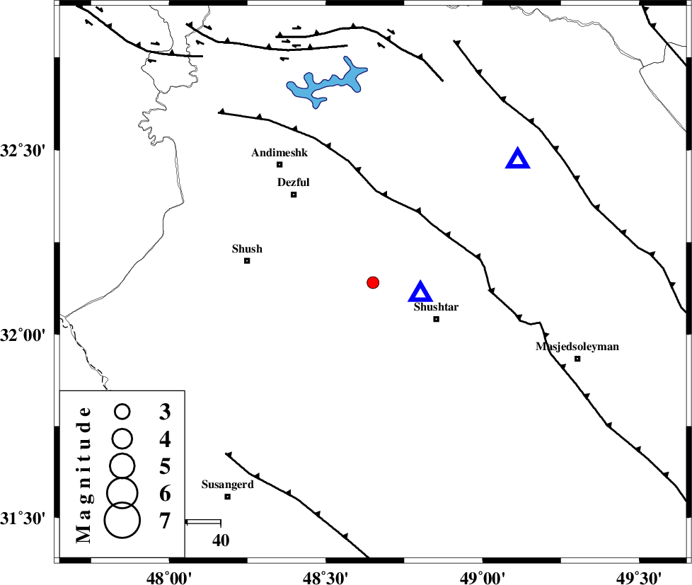
| Location | Lat:32.14 Lon: 48.65 |
| Region | Khoozestan Province, 23 km West of Shushtar |
Nearest Cities |
|
| 19 km South West of Gatvand, Khoozestan Province | |
| 19 km North West of Sardarabad, Khoozestan Province | |
| 20 km West of Samaleh, Khoozestan Province | |
| 22 km North West of Shushtar, Khoozestan Province | |
| 27 km South East of Shamsabad, Khoozestan Province | |
| Depth | 15 km |
| Agency | |
Faults within 150 km: |
|
| DEZFUL_EMBAYMENT (Length: 228 km) , Distance to epicenter: 25 km | |
| BALARUD_F_Z2 (Length: 58 km) , Distance to epicenter: 64 km | |
| MFF2 (Length: 205 km) , Distance to epicenter: 67 km | |
| Number of Phases | 5 |
| RMS | 0.1 |
| Number of Stations | 3 |
| Error in Latitude | >4.5 km |
| Error in Longitude | 4.7 km |
| Error in Depth | 3.4 km |
Download waveform in seisan format
to download seisan software Click here
to access information about IIEES stations Click here
Amplitude | ||||||||
| UID | Agency | Station | Component | Amplitude | Period | Arrival Time | Proccessing Time | Signal Clip |
| 89506 | IIEES | SHGR | E | 713.8 | 0.28 | 2013-05-31 14:41:09 | 2013-05-31 04:58:00 | n |
| 89507 | IIEES | KHMZ | N | 25.9 | 0.52 | 2013-05-31 14:42:04 | 2013-05-31 04:58:00 | n |
| 89508 | IIEES | KHMZ | E | 36.1 | 0.6 | 2013-05-31 14:42:06 | 2013-05-31 04:58:00 | n |
Phase | ||||||||||||
| Agency | Station | Component | Phase Type | Phase Quality | First Motion | Observed Arrival Time | Time Residual | Loc. Flag | Input Weight | Distance | Azimuth | |
| IIEES | SHGR | Z | Pg | E | 2013-05-31 14:41:01 | -0.07 | y | 15.2 | 104 | |||
| IIEES | SHGR | N | Sg | E | 2013-05-31 14:41:04 | 0.05 | y | 15.2 | 104 | |||
| IIEES | KHMZ | Z | Pg | E | 2013-05-31 14:41:33 | -0.01 | y | 216 | 34 | |||
| IIEES | KHMZ | N | S | E | 2013-05-31 14:41:57 | -0.03 | y | 216 | 34 | |||
| IIEES | ASAO | Z | Pn | E | 2013-05-31 14:41:42 | 0.07 | y | 296 | 25 | |||