
Magnitude |
2.1 |
| Date & Time (UTC) | 2013-06-02 12:00:50.1 |
| Date & Time (Local) | 1392/3/12 16:30:50.1 |
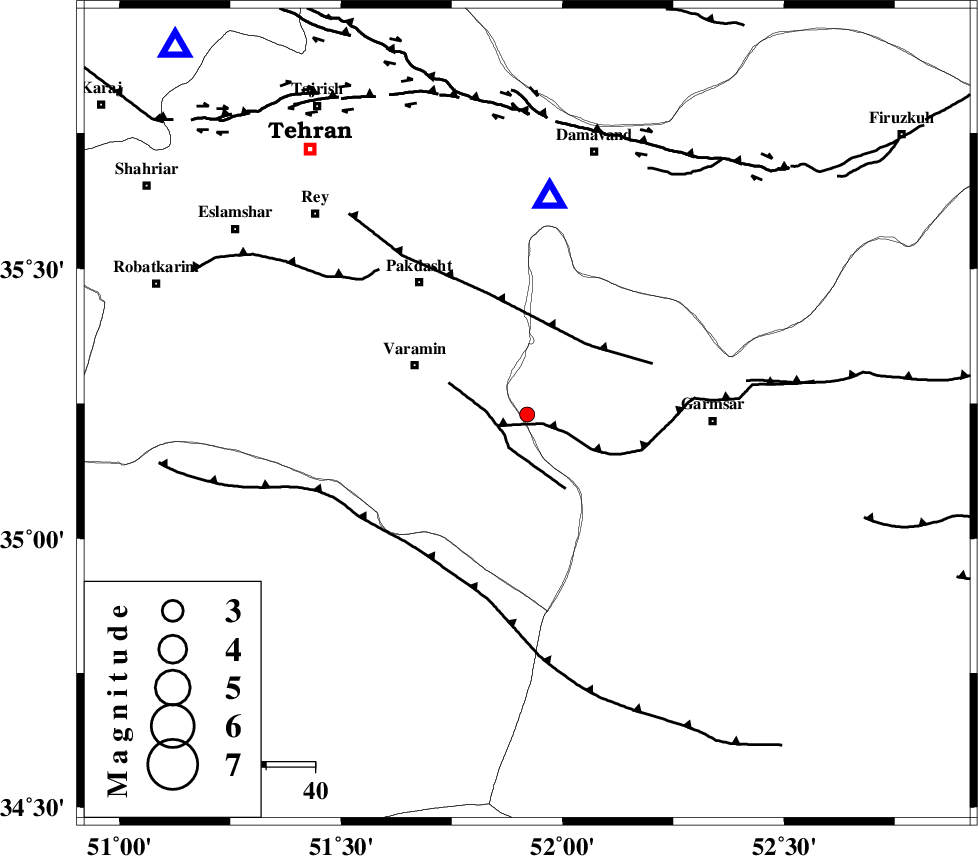
| Location | Lat:35.23 Lon: 51.92 |
| Region | Semnan Province, 25 km East of Varamin |
Nearest Cities |
|
| 7 km of Shorqazi, Semnan Province | |
| 9 km of Cheshmeh nadi, Semnan Province | |
| 18 km South West of Evanekay, Semnan Province | |
| 19 km East of Pishva, Tehran Province | |
| 20 km South East of Khalilabad, Tehran Province | |
| Depth | 31 km |
| Agency | |
Faults within 150 km: |
|
| GARMSAR_F (Length: 77 km) , Distance to epicenter: 2 km | |
| PISHAV_F (Length: 34 km) , Distance to epicenter: 6 km | |
| EYVANEKEY_F (Length: 74 km) , Distance to epicenter: 19 km | |
| Number of Phases | 6 |
| RMS | 0.1 |
| Number of Stations | 3 |
| Error in Latitude | >2 km |
| Error in Longitude | 3.8 km |
| Error in Depth | 6.9 km |
Download waveform in seisan format
to download seisan software Click here
to access information about IIEES stations Click here
Amplitude | ||||||||
| UID | Agency | Station | Component | Amplitude | Period | Arrival Time | Proccessing Time | Signal Clip |
| 89522 | IIEES | DAMV | E | 157.4 | 0.08 | 2013-06-02 12:01:06 | 2013-06-02 02:10:00 | n |
| 89523 | IIEES | GHVR | E | 46.6 | 0.28 | 2013-06-02 12:01:25 | 2013-06-02 02:10:00 | n |
Phase | ||||||||||||
| Agency | Station | Component | Phase Type | Phase Quality | First Motion | Observed Arrival Time | Time Residual | Loc. Flag | Input Weight | Distance | Azimuth | |
| IIEES | DAMV | Z | Pg | E | 2013-06-02 12:00:59 | -0.08 | y | 45.1 | 6 | |||
| IIEES | DAMV | E | Sg | E | 2013-06-02 12:01:06 | 0.05 | y | 45.1 | 6 | |||
| IIEES | GHVR | Z | Pg | E | 2013-06-02 12:01:07 | -0.08 | y | 103 | 217 | |||
| IIEES | GHVR | N | Sg | E | 2013-06-02 12:01:20 | 0.05 | y | 103 | 217 | |||
| IIEES | ASAO | Z | Pg | E | 2013-06-02 12:01:20 | 0.17 | y | 188 | 247 | |||
| IIEES | ASAO | E | Sg | E | 2013-06-02 12:01:43 | -0.1 | y | 188 | 247 | |||