
Magnitude |
3.7 |
| Date & Time (UTC) | 2013-06-03 13:16:31.6 |
| Date & Time (Local) | 1392/3/13 17:46:31.6 |
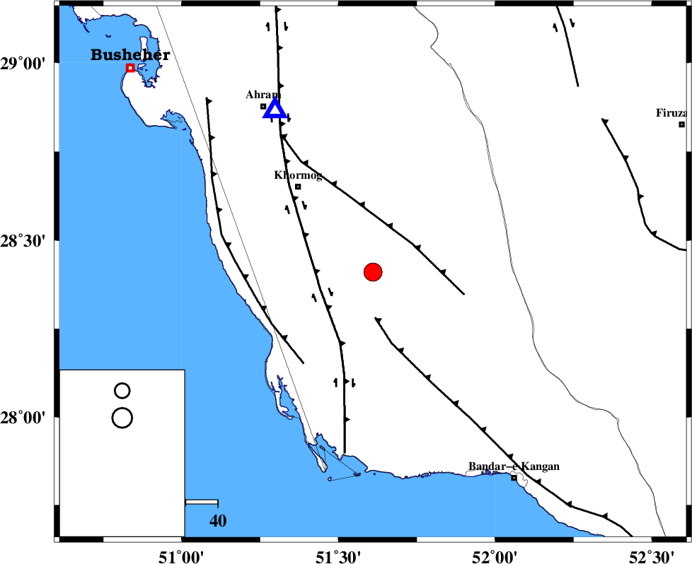
| Location | Lat:28.41 Lon: 51.61 |
| Region | Bushehr Province, 36 km South-East of Khormog |
Nearest Cities |
|
| 11 km North East of Baduleh, Bushehr Province | |
| 12 km North of Kaki, Bushehr Province | |
| 15 km North West of Shanbeh, Bushehr Province | |
| 28 km North of Abkesh, Bushehr Province | |
| 31 km South East of Buheyri, Bushehr Province | |
| Depth | 31 km |
| Agency | |
Faults within 150 km: |
|
| MFF3 (Length: 292 km) , Distance to epicenter: 14 km | |
| MFF5 (Length: 74 km) , Distance to epicenter: 15 km | |
| BORAZJAN_F (Length: 168 km) , Distance to epicenter: 17 km | |
| Number of Phases | 4 |
| RMS | 0.3 |
| Number of Stations | 4 |
| Error in Latitude | >2.6 km |
| Error in Longitude | 2.2 km |
| Error in Depth | 0 km |
Download waveform in seisan format
to download seisan software Click here
to access information about IIEES stations Click here
Amplitude | ||||||||
| UID | Agency | Station | Component | Amplitude | Period | Arrival Time | Proccessing Time | Signal Clip |
| 89534 | IIEES | AHRM | N | 4410.1 | 0.4 | 2013-06-03 13:16:58 | 2013-06-03 03:10:00 | n |
| 89535 | IIEES | GHIR | N | 1112.9 | 0.48 | 2013-06-03 13:17:13 | 2013-06-03 03:10:00 | n |
| 89536 | IIEES | GHIR | E | 1604.3 | 0.68 | 2013-06-03 13:17:15 | 2013-06-03 03:10:00 | n |
Phase | ||||||||||||
| Agency | Station | Component | Phase Type | Phase Quality | First Motion | Observed Arrival Time | Time Residual | Loc. Flag | Input Weight | Distance | Azimuth | |
| IIEES | AHRM | Z | Pg | E | 2013-06-03 13:16:42 | -0.13 | y | 59.2 | 329 | |||
| IIEES | GHIR | Z | Pg | E | 2013-06-03 13:16:54 | 0.17 | y | 136 | 95 | |||
| IIEES | KRBR | Z | Pn | E | 2013-06-03 13:17:43 | -0.46 | y | 531 | 70 | |||
| IIEES | GHVR | Z | Pn | E | 2013-06-03 13:18:02 | 0.52 | y | 674 | 357 | |||