
Magnitude |
2.5 |
| Date & Time (UTC) | 2013-06-04 12:58:21.3 |
| Date & Time (Local) | 1392/3/14 17:28:21.3 |
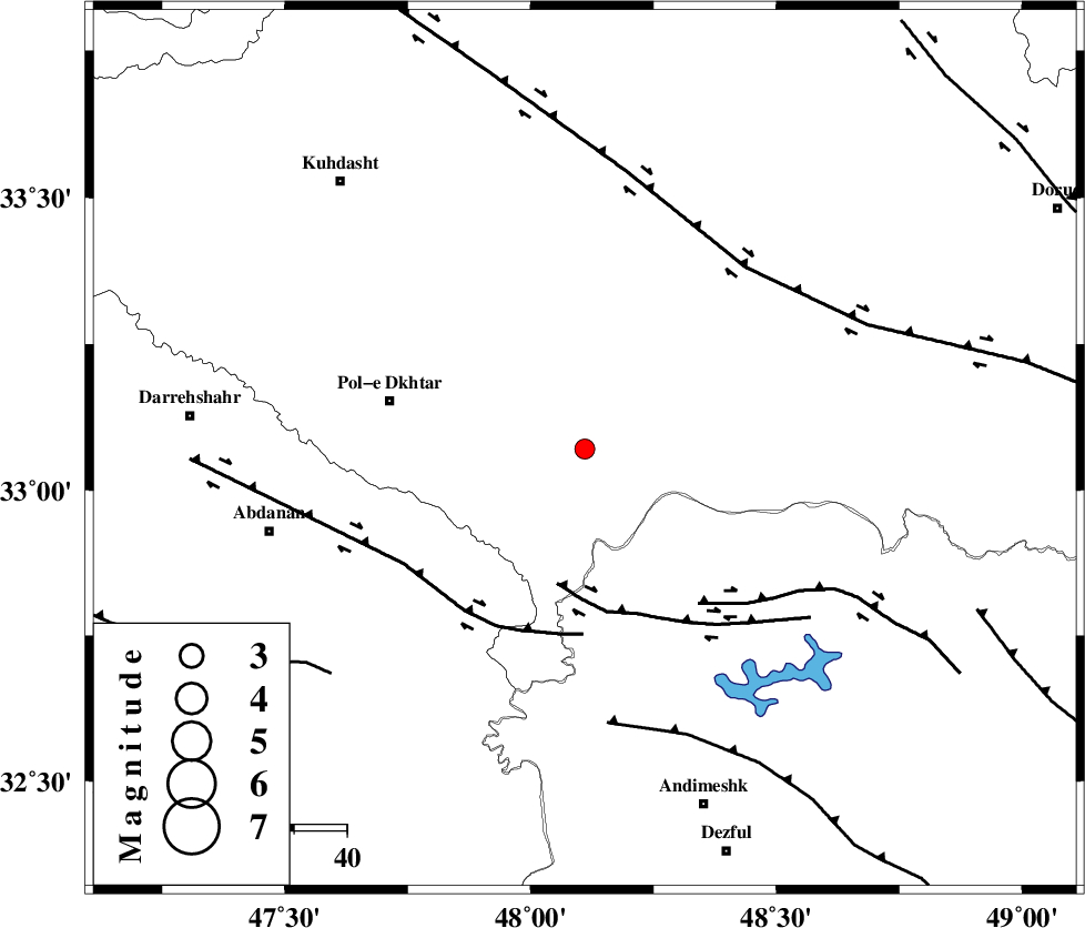
| Location | Lat:33.07 Lon: 48.11 |
| Region | Lorestan Province, 38 km East of Pol-e dokhtar |
Nearest Cities |
|
| 36 km South East of Maeulan, Lorestan Province | |
| 37 km North West of Bidruyeh, Khoozestan Province | |
| 37 km South of Shoorab-e sofla, Lorestan Province | |
| 38 km East of Pol-e dokhtar, Lorestan Province | |
| 39 km North West of Sorkhakan, Khoozestan Province | |
| Depth | 14 km |
| Agency | |
Faults within 150 km: |
|
| BALARUD_F_Z3 (Length: 53 km) , Distance to epicenter: 26 km | |
| BALARUD_F_Z1 (Length: 87 km) , Distance to epicenter: 35 km | |
| BALARUD_F_Z2 (Length: 58 km) , Distance to epicenter: 36 km | |
| Number of Phases | 4 |
| RMS | 0 |
| Number of Stations | 3 |
| Error in Latitude | >13.3 km |
| Error in Longitude | 12.1 km |
| Error in Depth | 7.7 km |
Download waveform in seisan format
to download seisan software Click here
to access information about IIEES stations Click here
Amplitude | ||||||||
| UID | Agency | Station | Component | Amplitude | Period | Arrival Time | Proccessing Time | Signal Clip |
| 89543 | IIEES | KHMZ | E | 30.4 | 0.44 | 2013-06-04 12:59:26 | 2013-06-04 02:53:00 | n |
| 89544 | IIEES | GHVR | E | 24.7 | 0.6 | 2013-06-04 12:59:57 | 2013-06-04 02:53:00 | n |
Phase | ||||||||||||
| Agency | Station | Component | Phase Type | Phase Quality | First Motion | Observed Arrival Time | Time Residual | Loc. Flag | Input Weight | Distance | Azimuth | |
| IIEES | KHMZ | Z | Pg | E | 2013-06-04 12:58:52 | -0.02 | y | 188 | 66 | |||
| IIEES | ASAO | Z | Pn | E | 2013-06-04 12:58:59 | -0.01 | y | 242 | 47 | |||
| IIEES | GHVR | Z | Pn | E | 2013-06-04 12:59:10 | 0.03 | y | 330 | 61 | |||
| IIEES | GHVR | N | Sg | E | 2013-06-04 12:59:53 | 0 | y | 330 | 61 | |||