
Magnitude |
2.7 |
| Date & Time (UTC) | 2013-06-15 00:48:15.7 |
| Date & Time (Local) | 1392/3/25 05:18:15.7 |
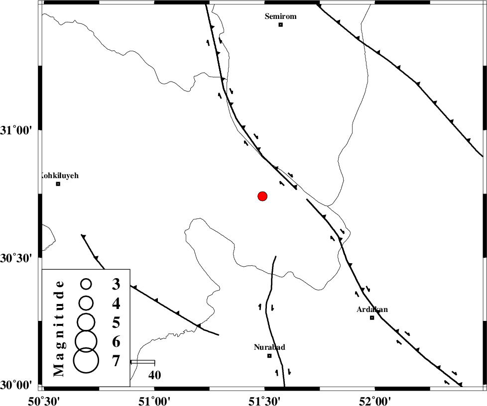
| Location | Lat:30.74 Lon: 51.49 |
| Region | Kohkiluieh va boyerahmad Province, 11 km Yasuj |
Nearest Cities |
|
| 11 km of Kerik, Kohkiluieh va boyerahmad Province | |
| 11 km North of Yasuj, Kohkiluieh va boyerahmad Province | |
| 14 km South of Sisakht, Kohkiluieh va boyerahmad Province | |
| 17 km North of Tal-e khosro, Kohkiluieh va boyerahmad Province | |
| 19 km East of Chitab, Kohkiluieh va boyerahmad Province | |
| Depth | 15 km |
| Agency | |
Faults within 150 km: |
|
| DENA_F (Length: 137 km) , Distance to epicenter: 15 km | |
| HZF3 (Length: 197 km) , Distance to epicenter: 19 km | |
| KAZERUN_F (Length: 96 km) , Distance to epicenter: 27 km | |
| Number of Phases | 4 |
| RMS | 0.2 |
| Number of Stations | 4 |
| Error in Latitude | >2.5 km |
| Error in Longitude | 2.9 km |
| Error in Depth | 0 km |
Download waveform in seisan format
to download seisan software Click here
to access information about IIEES stations Click here
Amplitude | ||||||||
| UID | Agency | Station | Component | Amplitude | Period | Arrival Time | Proccessing Time | Signal Clip |
| 89646 | IIEES | NASN | N | 38.3 | 0.6 | 2013-06-15 00:49:33 | 2013-06-15 02:08:00 | n |
| 89647 | IIEES | GHIR | N | 25.9 | 0.44 | 2013-06-15 00:50:04 | 2013-06-15 02:08:00 | n |
| 89648 | IIEES | GHIR | E | 41.4 | 0.48 | 2013-06-15 00:50:07 | 2013-06-15 02:08:00 | n |
Phase | ||||||||||||
| Agency | Station | Component | Phase Type | Phase Quality | First Motion | Observed Arrival Time | Time Residual | Loc. Flag | Input Weight | Distance | Azimuth | |
| IIEES | NASN | Z | Pn | E | 2013-06-15 00:48:56 | 0.23 | y | 261 | 28 | |||
| IIEES | GHIR | Z | Pn | E | 2013-06-15 00:49:01 | 0.04 | y | 308 | 151 | |||
| IIEES | YZKH | Z | Pn | E | 2013-06-15 00:49:06 | -0.22 | y | 347 | 57 | |||
| IIEES | KHMZ | Z | Pn | E | 2013-06-15 00:49:08 | -0.09 | y | 363 | 337 | |||