
Magnitude |
2.3 |
| Date & Time (UTC) | 2013-06-20 07:38:08.7 |
| Date & Time (Local) | 1392/3/30 12:08:08.7 |
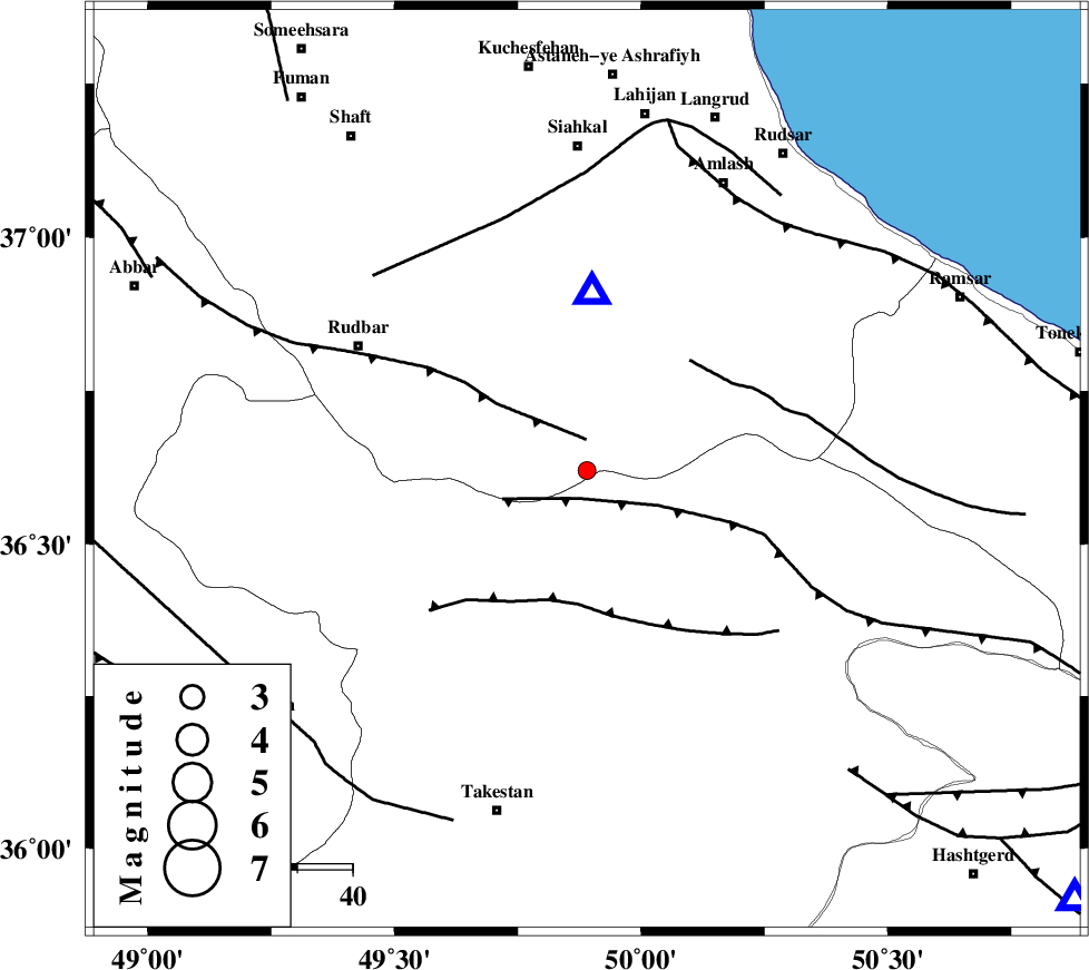
| Location | Lat:36.62 Lon: 49.89 |
| Region | Gilan Province, 40 km North-West of Qazvin |
Nearest Cities |
|
| 13 km East of Jirhandeh, Gilan Province | |
| 14 km South of Kelishom, Gilan Province | |
| 26 km South of Barresar, Gilan Province | |
| 32 km North East of Kuhgir-e sofla, Ghazvin Province | |
| 33 km North East of Aqababa, Ghazvin Province | |
| Depth | 14 km |
| Agency | |
Faults within 150 km: |
|
| ALAMUTRUD_F (Length: 140 km) , Distance to epicenter: 5 km | |
| RUDBAR_F (Length: 93 km) , Distance to epicenter: 6 km | |
| N_QAZVIN_F (Length: 72 km) , Distance to epicenter: 24 km | |
| Number of Phases | 4 |
| RMS | 0.1 |
| Number of Stations | 3 |
| Error in Latitude | >4 km |
| Error in Longitude | 3.8 km |
| Error in Depth | 5.1 km |
Download waveform in seisan format
to download seisan software Click here
to access information about IIEES stations Click here
Amplitude | ||||||||
| UID | Agency | Station | Component | Amplitude | Period | Arrival Time | Proccessing Time | Signal Clip |
| 89695 | IIEES | ZNJK | N | 66.1 | 0.16 | 2013-06-20 07:38:45 | 2013-06-20 10:21:00 | n |
| 89696 | IIEES | GHVR | N | 20.5 | 0.56 | 2013-06-20 07:39:28 | 2013-06-20 10:21:00 | n |
| 89697 | IIEES | GHVR | E | 20.1 | 0.48 | 2013-06-20 07:39:31 | 2013-06-20 10:21:00 | n |
Phase | ||||||||||||
| Agency | Station | Component | Phase Type | Phase Quality | First Motion | Observed Arrival Time | Time Residual | Loc. Flag | Input Weight | Distance | Azimuth | |
| IIEES | ZNJK | Z | Pg | E | 2013-06-20 07:38:27 | -0.05 | y | 108 | 274 | |||
| IIEES | CHTH | Z | Pg | E | 2013-06-20 07:38:31 | -0.09 | y | 136 | 125 | |||
| IIEES | GHVR | N | Pn | E | 2013-06-20 07:38:49 | 0.2 | y | 267 | 152 | |||
| IIEES | GHVR | E | Sg | E | 2013-06-20 07:39:23 | -0.06 | y | 267 | 152 | |||