
Magnitude |
3.1 |
| Date & Time (UTC) | 2013-06-20 11:38:13.4 |
| Date & Time (Local) | 1392/3/30 16:08:13.4 |
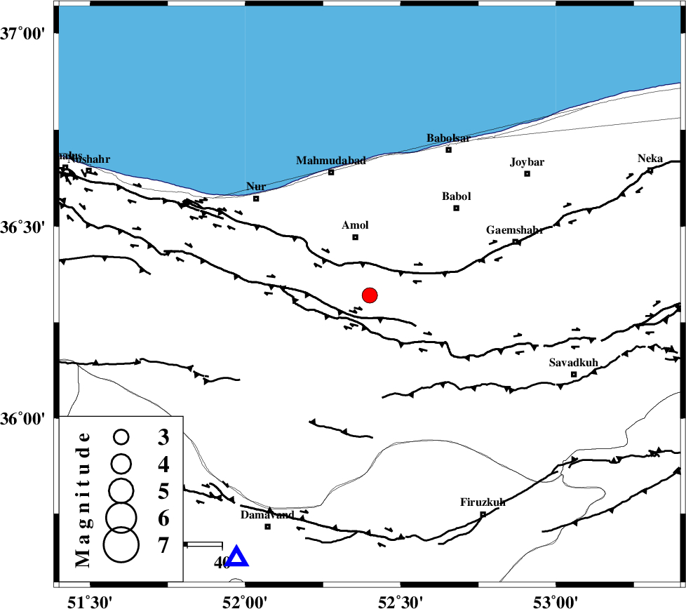
| Location | Lat:36.32 Lon: 52.4 |
| Region | Mazandaran Province, 17 km South of Amol |
Nearest Cities |
|
| 4 km of Razkeh, Mazandaran Province | |
| 11 km of Oskumahalleh, Mazandaran Province | |
| 14 km West of Khoshrud, Mazandaran Province | |
| 17 km South of Amol, Mazandaran Province | |
| 24 km South West of Paeen-e ahmad chalehpey, Mazandaran Province | |
| Depth | 14 km |
| Agency | |
Faults within 150 km: |
|
| N_ALBORZ_F (Length: 360 km) , Distance to epicenter: 7 km | |
| KHAZAR_F (Length: 523 km) , Distance to epicenter: 8 km | |
| KANDOVAN_F (Length: 90 km) , Distance to epicenter: 53 km | |
| Number of Phases | 5 |
| RMS | 0.2 |
| Number of Stations | 4 |
| Error in Latitude | >4.6 km |
| Error in Longitude | 5.9 km |
| Error in Depth | 8.4 km |
Download waveform in seisan format
to download seisan software Click here
to access information about IIEES stations Click here
Amplitude | ||||||||
| UID | Agency | Station | Component | Amplitude | Period | Arrival Time | Proccessing Time | Signal Clip |
| 89698 | IIEES | THKV | N | 299.3 | 0.28 | 2013-06-20 11:38:42 | 2013-06-20 01:05:00 | n |
Phase | ||||||||||||
| Agency | Station | Component | Phase Type | Phase Quality | First Motion | Observed Arrival Time | Time Residual | Loc. Flag | Input Weight | Distance | Azimuth | |
| IIEES | DAMV | Z | Pg | E | 2013-06-20 11:38:28 | 0.22 | y | 85.5 | 207 | |||
| IIEES | CHTH | Z | Pg | E | 2013-06-20 11:38:33 | -0.32 | y | 123 | 249 | |||
| IIEES | CHTH | N | Sg | E | 2013-06-20 11:38:49 | 0.19 | y | 123 | 249 | |||
| IIEES | GHVR | Z | Pn | E | 2013-06-20 11:38:49 | 0.08 | y | 229 | 207 | |||
| IIEES | GHVR | N | Sg | E | 2013-06-20 11:39:18 | -0.16 | y | 229 | 207 | |||