
Magnitude |
4 |
| Date & Time (UTC) | 2013-06-22 17:46:22.0 |
| Date & Time (Local) | 1392/4/1 22:16:22.0 |
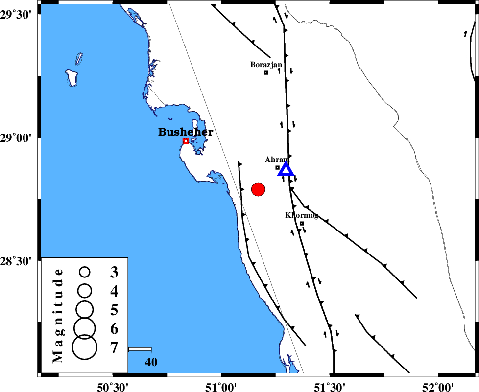
| Location | Lat:28.79 Lon: 51.17 |
| Region | Bushehr Province, 13 km Ahram |
Nearest Cities |
|
| 10 km North of Delvar, Bushehr Province | |
| 13 km of Ahram, Bushehr Province | |
| 19 km South of Bazuei, Bushehr Province | |
| 20 km North of Derazi, Bushehr Province | |
| 25 km North West of Khormog, Bushehr Province | |
| Depth | 42 km |
| Agency | |
Faults within 150 km: |
|
| ZFF2 (Length: 84 km) , Distance to epicenter: 8 km | |
| MFF5 (Length: 74 km) , Distance to epicenter: 14 km | |
| BORAZJAN_F (Length: 168 km) , Distance to epicenter: 14 km | |
| Number of Phases | 6 |
| RMS | 0 |
| Number of Stations | 5 |
| Error in Latitude | >4.5 km |
| Error in Longitude | 6.7 km |
| Error in Depth | 5.8 km |
Download waveform in seisan format
to download seisan software Click here
to access information about IIEES stations Click here
Amplitude | ||||||||
| UID | Agency | Station | Component | Amplitude | Period | Arrival Time | Proccessing Time | Signal Clip |
| 89709 | IIEES | GHIR | N | 1342.7 | 0.4 | 2013-06-22 17:47:19 | 2013-06-22 07:36:00 | n |
| 89710 | IIEES | GHIR | E | 1660.3 | 0.52 | 2013-06-22 17:47:26 | 2013-06-22 07:36:00 | n |
Phase | ||||||||||||
| Agency | Station | Component | Phase Type | Phase Quality | First Motion | Observed Arrival Time | Time Residual | Loc. Flag | Input Weight | Distance | Azimuth | |
| IIEES | GHIR | Z | P | E | 2013-06-22 17:46:50 | 0 | y | 186 | 107 | |||
| IIEES | GHIR | N | Sg | E | 2013-06-22 17:47:14 | 0 | y | 186 | 107 | |||
| IIEES | NASN | Z | P | E | 2013-06-22 17:47:26 | 0.01 | y | 471 | 19 | |||
| IIEES | YZKH | Z | P | E | 2013-06-22 17:47:31 | -0.04 | y | 517 | 39 | |||
| IIEES | KHMZ | Z | P | E | 2013-06-22 17:47:36 | -0.07 | y | 561 | 348 | |||
| IIEES | GHVR | Z | P | E | 2013-06-22 17:47:45 | 0.1 | y | 631 | 1 | |||