
Magnitude |
2.2 |
| Date & Time (UTC) | 2013-06-23 01:55:37.7 |
| Date & Time (Local) | 1392/4/2 06:25:37.7 |
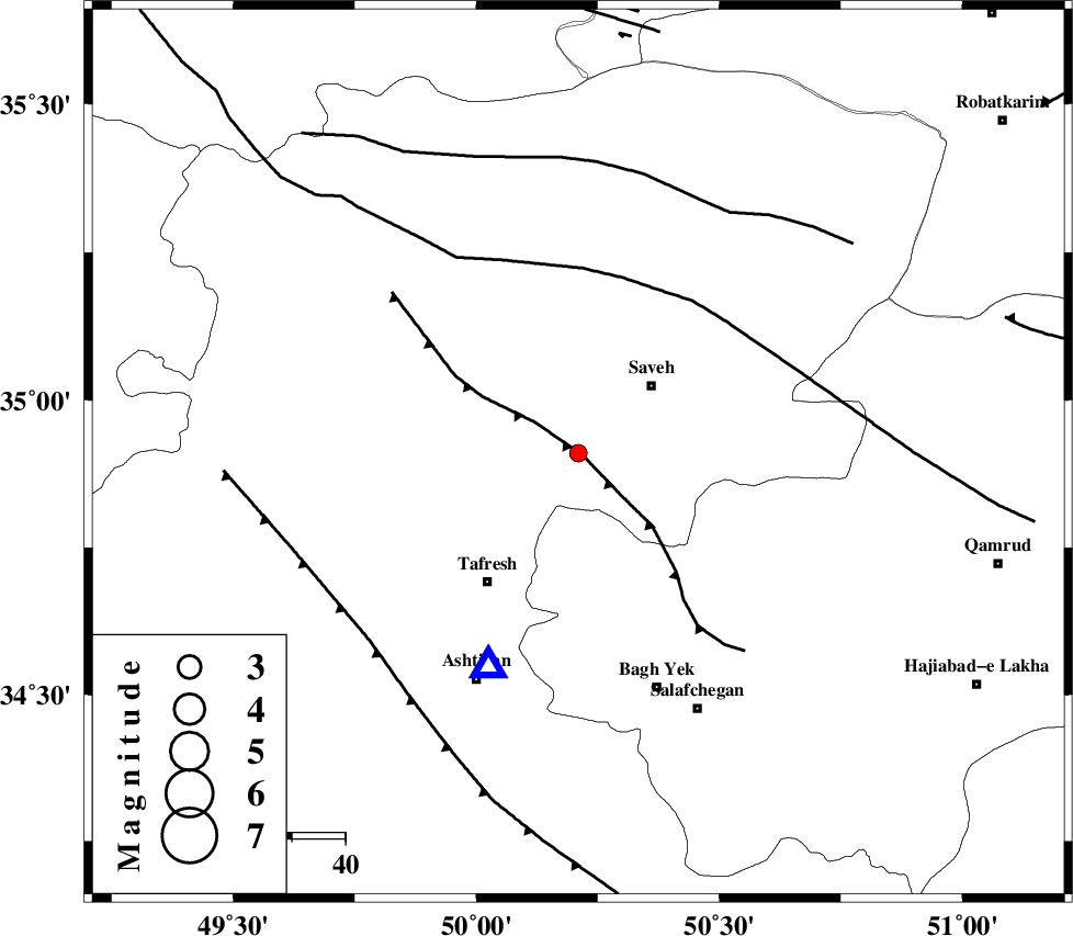
| Location | Lat:34.91 Lon: 50.21 |
| Region | Markazi Province, 19 km South-West of Saveh |
Nearest Cities |
|
| 10 km of Yalabad, Markazi Province | |
| 14 km North East of Khanak, Markazi Province | |
| 15 km North West of Qareh chay, Markazi Province | |
| 19 km South West of Saveh, Markazi Province | |
| 23 km South East of Qeytaniyeh, Markazi Province | |
| Depth | 18 km |
| Agency | |
Faults within 150 km: |
|
| INDES_F (Length: 98 km) , Distance to epicenter: 1 km | |
| KUSHK_E_NOSRAT_F (Length: 230 km) , Distance to epicenter: 34 km | |
| TAFRESH_F (Length: 117 km) , Distance to epicenter: 53 km | |
| Number of Phases | 5 |
| RMS | 0.1 |
| Number of Stations | 5 |
| Error in Latitude | >2 km |
| Error in Longitude | 3.5 km |
| Error in Depth | 4 km |
Download waveform in seisan format
to download seisan software Click here
to access information about IIEES stations Click here
Amplitude | ||||||||
| UID | Agency | Station | Component | Amplitude | Period | Arrival Time | Proccessing Time | Signal Clip |
| 89719 | IIEES | ASAO | E | 186.3 | 0.24 | 2013-06-23 01:55:53 | 2013-06-23 03:26:00 | n |
| 89720 | IIEES | KHMZ | E | 52.7 | 0.24 | 2013-06-23 01:56:17 | 2013-06-23 03:26:00 | n |
| 89721 | IIEES | KHMZ | N | 54 | 0.48 | 2013-06-23 01:56:17 | 2013-06-23 03:26:00 | n |
| 89722 | IIEES | DAMV | E | 27.9 | 0.44 | 2013-06-23 01:56:31 | 2013-06-23 03:26:00 | n |
Phase | ||||||||||||
| Agency | Station | Component | Phase Type | Phase Quality | First Motion | Observed Arrival Time | Time Residual | Loc. Flag | Input Weight | Distance | Azimuth | |
| IIEES | ASAO | Z | Pg | E | 2013-06-23 01:55:46 | 0.1 | y | 43.3 | 203 | |||
| IIEES | GHVR | Z | Pg | E | 2013-06-23 01:55:55 | 0.02 | y | 106 | 116 | |||
| IIEES | KHMZ | Z | Pg | E | 2013-06-23 01:55:59 | -0.12 | y | 132 | 190 | |||
| IIEES | CHTH | Z | Pg | E | 2013-06-23 01:56:00 | -0.04 | y | 139 | 37 | |||
| IIEES | DAMV | E | Pn | E | 2013-06-23 01:56:07 | 0.03 | y | 179 | 63 | |||