
Magnitude |
2.3 |
| Date & Time (UTC) | 2013-06-24 11:30:11.9 |
| Date & Time (Local) | 1392/4/3 16:00:11.9 |
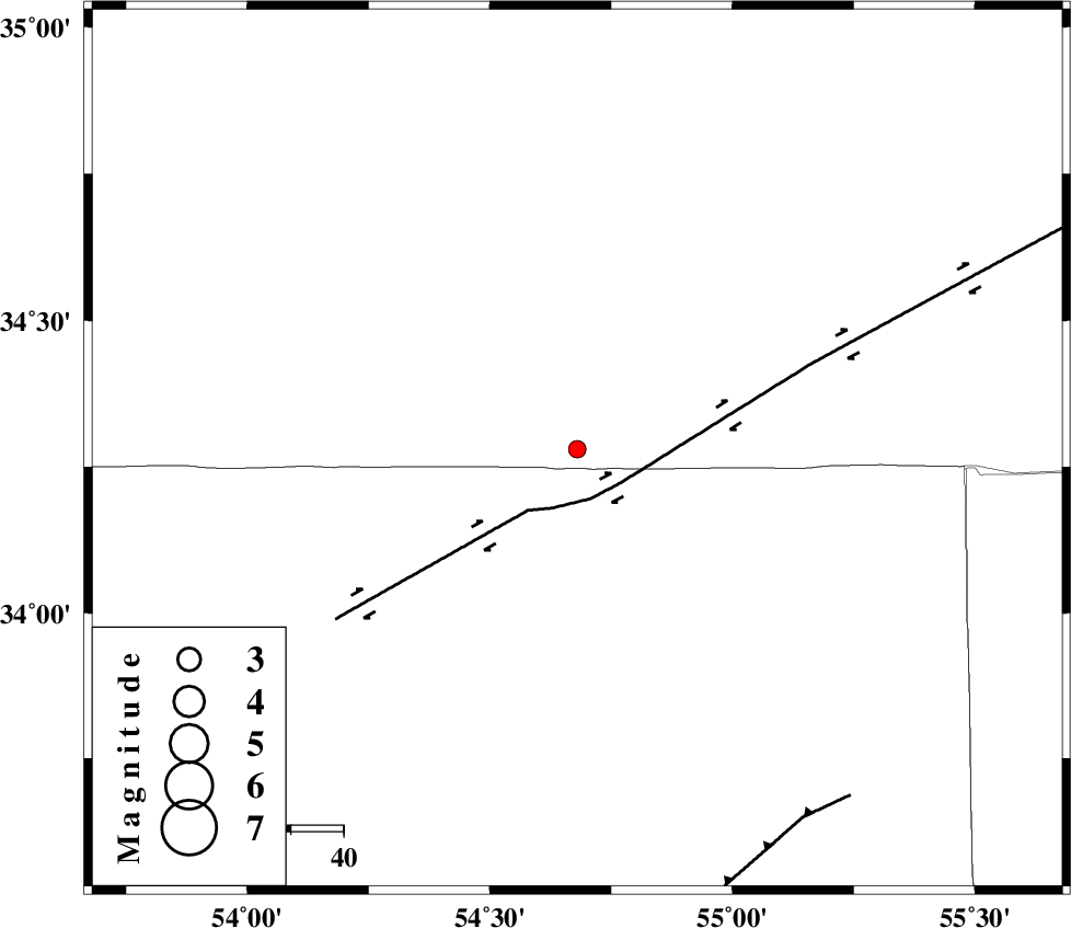
| Location | Lat:34.28 Lon: 54.68 |
| Region | Semnan Province, 212 km South-East of Damghan |
Nearest Cities |
|
| 36 km North East of Jondaq, Esfahan Province | |
| 54 km North West of Farrokhi, Esfahan Province | |
| 67 km North West of Khur, Esfahan Province | |
| 79 km North East of Chupanan, Esfahan Province | |
| 97 km North West of Mehranjan, Esfahan Province | |
| Depth | 18 km |
| Agency | |
Faults within 150 km: |
|
| DORUNEH_F (Length: 713 km) , Distance to epicenter: 10 km | |
| BIABANAK_F (Length: 162 km) , Distance to epicenter: 82 km | |
| TORUD_F (Length: 136 km) , Distance to epicenter: 111 km | |
| Number of Phases | 5 |
| RMS | 0 |
| Number of Stations | 4 |
| Error in Latitude | >4.3 km |
| Error in Longitude | 3.2 km |
| Error in Depth | 7.3 km |
Download waveform in seisan format
to download seisan software Click here
to access information about IIEES stations Click here
Amplitude | ||||||||
| UID | Agency | Station | Component | Amplitude | Period | Arrival Time | Proccessing Time | Signal Clip |
| 89744 | IIEES | GHVR | E | 10.9 | 0.44 | 2013-06-24 11:31:38 | 2013-06-24 01:10:00 | n |
| 89745 | IIEES | GHVR | N | 10.8 | 0.36 | 2013-06-24 11:31:38 | 2013-06-24 01:10:00 | n |
Phase | ||||||||||||
| Agency | Station | Component | Phase Type | Phase Quality | First Motion | Observed Arrival Time | Time Residual | Loc. Flag | Input Weight | Distance | Azimuth | |
| IIEES | YZKH | N | Pn | E | 2013-06-24 11:30:45 | -0.01 | y | 209 | 182 | |||
| IIEES | YZKH | N | Sg | E | 2013-06-24 11:31:11 | 0 | y | 209 | 182 | |||
| IIEES | TABS | Z | Pn | E | 2013-06-24 11:30:48 | -0.01 | y | 236 | 106 | |||
| IIEES | TABS | N | Sg | E | 2013-06-24 11:31:18 | 0.01 | y | 236 | 106 | |||
| IIEES | NASN | Z | Pn | E | 2013-06-24 11:30:49 | 0.02 | y | 239 | 227 | |||