
Magnitude |
3.8 |
| Date & Time (UTC) | 2013-06-28 21:16:21.2 |
| Date & Time (Local) | 1392/4/8 01:46:21.2 |
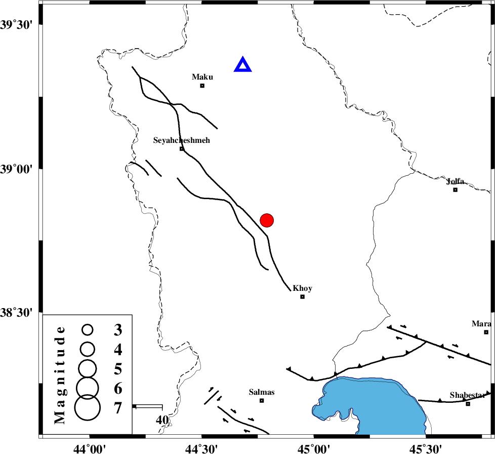
| Location | Lat:38.82 Lon: 44.79 |
| Region | Azarbaijan Gharbi Province, 32 km North-West of Khoy |
Nearest Cities |
|
| 16 km West of Bastam, Azarbaijan Gharbi Province | |
| 20 km North East of Zarabad, Azarbaijan Gharbi Province | |
| 23 km West of Churas, Azarbaijan Gharbi Province | |
| 24 km North West of Dizaj, Azarbaijan Gharbi Province | |
| 24 km South East of Qarantu, Azarbaijan Gharbi Province | |
| Depth | 17 km |
| Agency | |
Faults within 150 km: |
|
| KHOY (Length: 100 km) , Distance to epicenter: 10 km | |
| N_TABRIZ_F3 (Length: 66 km) , Distance to epicenter: 58 km | |
| N_TABRIZ_F1 (Length: 222 km) , Distance to epicenter: 62 km | |
| Number of Phases | 5 |
| RMS | 0 |
| Number of Stations | 5 |
| Error in Latitude | >4.9 km |
| Error in Longitude | 7.3 km |
| Error in Depth | 5.4 km |
Download waveform in seisan format
to download seisan software Click here
to access information about IIEES stations Click here
Amplitude | ||||||||
| UID | Agency | Station | Component | Amplitude | Period | Arrival Time | Proccessing Time | Signal Clip |
| 89779 | IIEES | BJRD | E | 2.5 | 0.44 | 2013-06-28 21:19:07 | 2013-06-28 11:25:00 | n |
Phase | ||||||||||||
| Agency | Station | Component | Phase Type | Phase Quality | First Motion | Observed Arrival Time | Time Residual | Loc. Flag | Input Weight | Distance | Azimuth | |
| IIEES | MAKU | Z | Pg | E | 2013-06-28 21:16:31 | 0 | y | 60.3 | 351 | |||
| IIEES | ZNJK | Z | Pn | E | 2013-06-28 21:17:20 | 0.03 | y | 418 | 124 | |||
| IIEES | ZNJK | N | Sg | E | 2013-06-28 21:18:18 | 0 | y | 418 | 124 | |||
| IIEES | SNGE | Z | Pn | E | 2013-06-28 21:17:27 | -0.01 | y | 472 | 150 | |||
| IIEES | CHTH | Z | Pn | E | 2013-06-28 21:17:49 | -0.04 | y | 647 | 118 | |||