
Magnitude |
2.3 |
| Date & Time (UTC) | 2013-06-30 08:08:36.9 |
| Date & Time (Local) | 1392/4/9 12:38:36.9 |
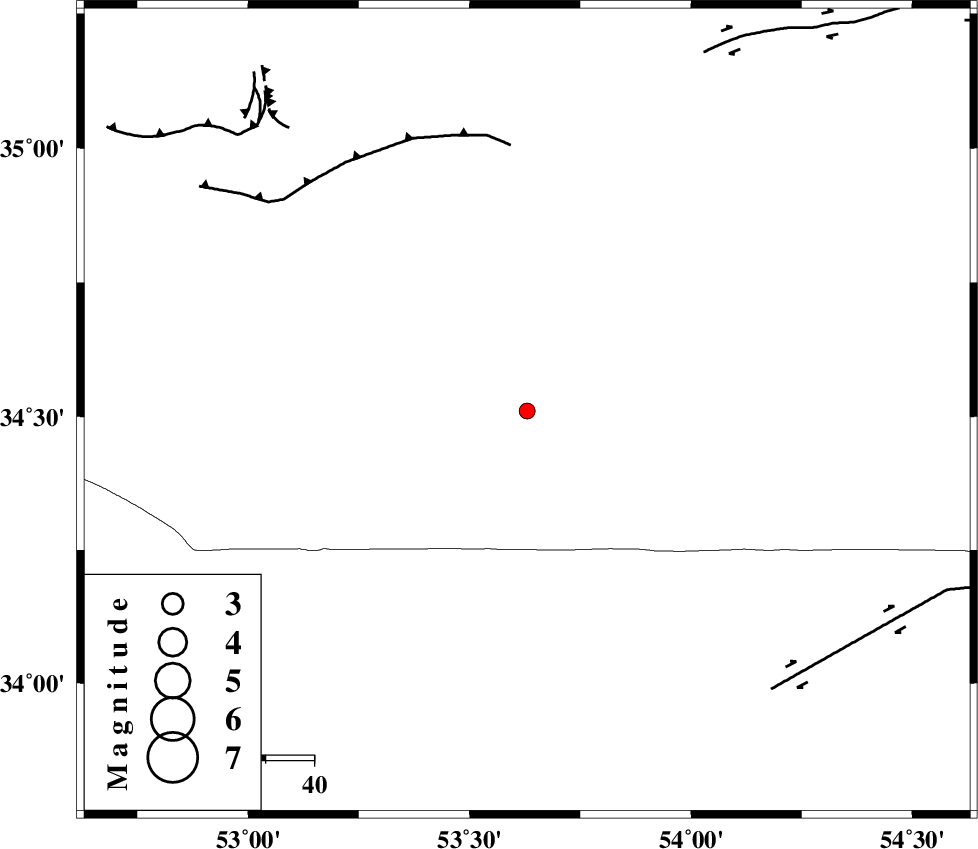
| Location | Lat:34.51 Lon: 53.63 |
| Region | Semnan Province, 119 km South-East of Semnan |
Nearest Cities |
|
| 89 km North West of Jondaq, Esfahan Province | |
| 99 km North East of Maedan, Esfahan Province | |
| 111 km South East of Lasjerd, Semnan Province | |
| 112 km South East of Sorkheh, Semnan Province | |
| 115 km South East of Alae, Semnan Province | |
| Depth | 14 km |
| Agency | |
Faults within 150 km: |
|
| KUH_E_GUGERD_F (Length: 73 km) , Distance to epicenter: 55 km | |
| DORUNEH_F (Length: 713 km) , Distance to epicenter: 77 km | |
| KUH_E_GACHAB_F1 (Length: 53 km) , Distance to epicenter: 82 km | |
| Number of Phases | 6 |
| RMS | 0 |
| Number of Stations | 4 |
| Error in Latitude | >1.9 km |
| Error in Longitude | 2.3 km |
| Error in Depth | 4.9 km |
Download waveform in seisan format
to download seisan software Click here
to access information about IIEES stations Click here
Amplitude | ||||||||
| UID | Agency | Station | Component | Amplitude | Period | Arrival Time | Proccessing Time | Signal Clip |
| 89787 | IIEES | DAMV | E | 27.1 | 0.16 | 2013-06-30 08:09:33 | 2013-06-30 09:38:00 | n |
| 89788 | IIEES | NASN | E | 29.8 | 0.16 | 2013-06-30 08:09:37 | 2013-06-30 09:38:00 | n |
Phase | ||||||||||||
| Agency | Station | Component | Phase Type | Phase Quality | First Motion | Observed Arrival Time | Time Residual | Loc. Flag | Input Weight | Distance | Azimuth | |
| IIEES | DAMV | Z | Pg | E | 2013-06-30 08:09:09 | 0.02 | y | 196 | 310 | |||
| IIEES | DAMV | E | Sg | E | 2013-06-30 08:09:32 | -0.03 | y | 196 | 310 | |||
| IIEES | NASN | Z | Pn | E | 2013-06-30 08:09:10 | -0.04 | y | 205 | 202 | |||
| IIEES | GHVR | Z | Pn | E | 2013-06-30 08:09:11 | 0.06 | y | 219 | 270 | |||
| IIEES | GHVR | E | Sg | E | 2013-06-30 08:09:39 | 0 | y | 219 | 270 | |||
| IIEES | YZKH | Z | Pn | E | 2013-06-30 08:09:16 | 0 | y | 252 | 159 | |||