
Magnitude |
3.4 |
| Date & Time (UTC) | 2013-06-30 18:06:15.5 |
| Date & Time (Local) | 1392/4/9 22:36:15.5 |
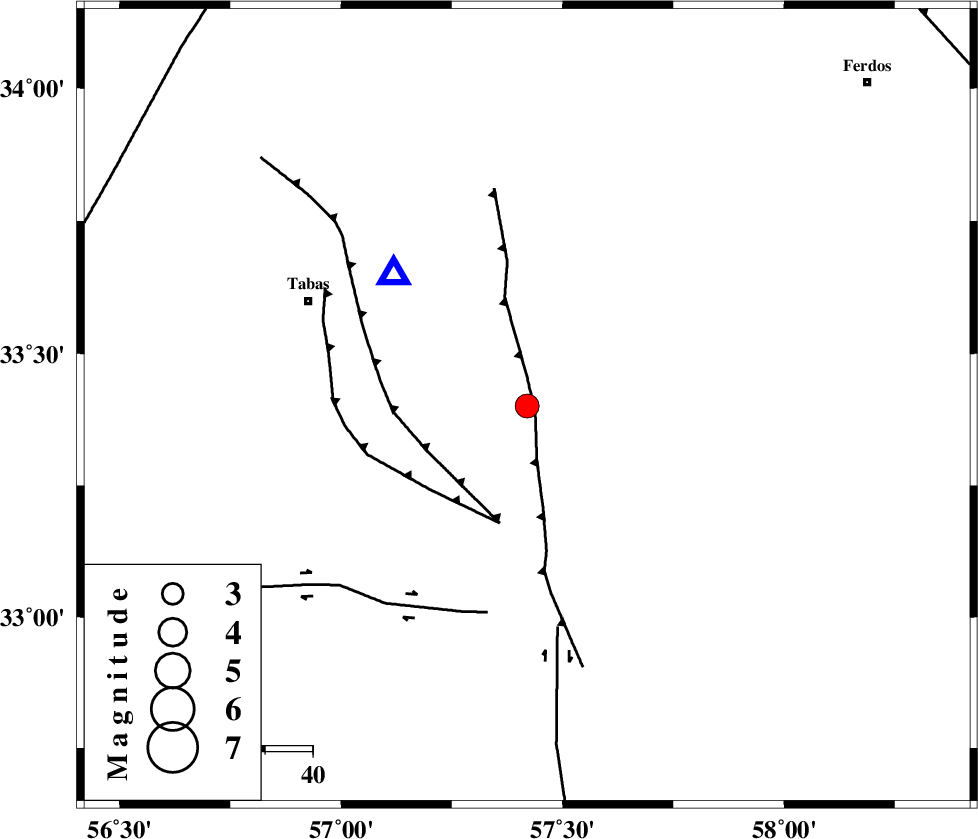
| Location | Lat:33.4 Lon: 57.42 |
| Region | Yazd Province, 51 km South-East of Tabas |
Nearest Cities |
|
| 14 km North of Dihuk, Yazd Province | |
| 33 km South of Arsak, Khorasan(center) Province | |
| 44 km North West of Arababad, Yazd Province | |
| 46 km East of Kerit, Yazd Province | |
| 49 km South East of Reqqeh, Khorasan(center) Province | |
| Depth | 17 km |
| Agency | |
Faults within 150 km: |
|
| ESFARDIAR_F (Length: 94 km) , Distance to epicenter: 2 km | |
| TABAS_F1 (Length: 91 km) , Distance to epicenter: 23 km | |
| TABAS_F2 (Length: 67 km) , Distance to epicenter: 25 km | |
| Number of Phases | 5 |
| RMS | 0.1 |
| Number of Stations | 4 |
| Error in Latitude | >4 km |
| Error in Longitude | 3.8 km |
| Error in Depth | 3.7 km |
Download waveform in seisan format
to download seisan software Click here
to access information about IIEES stations Click here
Amplitude | ||||||||
| UID | Agency | Station | Component | Amplitude | Period | Arrival Time | Proccessing Time | Signal Clip |
| 89792 | IIEES | YZKH | N | 165.9 | 0.36 | 2013-06-30 18:07:39 | 2013-06-30 07:32:00 | n |
| 89793 | IIEES | YZKH | E | 182.1 | 0.76 | 2013-06-30 18:07:44 | 2013-06-30 07:32:00 | n |
| 89794 | IIEES | KRBR | E | 84.9 | 0.36 | 2013-06-30 18:08:11 | 2013-06-30 07:32:00 | n |
| 89795 | IIEES | KRBR | N | 86.7 | 0.56 | 2013-06-30 18:08:17 | 2013-06-30 07:32:00 | n |
Phase | ||||||||||||
| Agency | Station | Component | Phase Type | Phase Quality | First Motion | Observed Arrival Time | Time Residual | Loc. Flag | Input Weight | Distance | Azimuth | |
| IIEES | TABS | Z | Pg | E | 2013-06-30 18:06:22 | -0.12 | y | 39.5 | 315 | |||
| IIEES | TABS | N | Sg | E | 2013-06-30 18:06:28 | 0.09 | y | 39.5 | 315 | |||
| IIEES | BSRN | Z | P | E | 2013-06-30 18:06:51 | 0.01 | y | 225 | 134 | |||
| IIEES | BSRN | N | Sg | E | 2013-06-30 18:07:19 | 0.01 | y | 225 | 134 | |||
| IIEES | YZKH | Z | Pn | E | 2013-06-30 18:06:58 | 0 | y | 288 | 248 | |||