
Magnitude |
2.4 |
| Date & Time (UTC) | 2013-07-09 11:15:53.5 |
| Date & Time (Local) | 1392/4/18 15:45:53.5 |
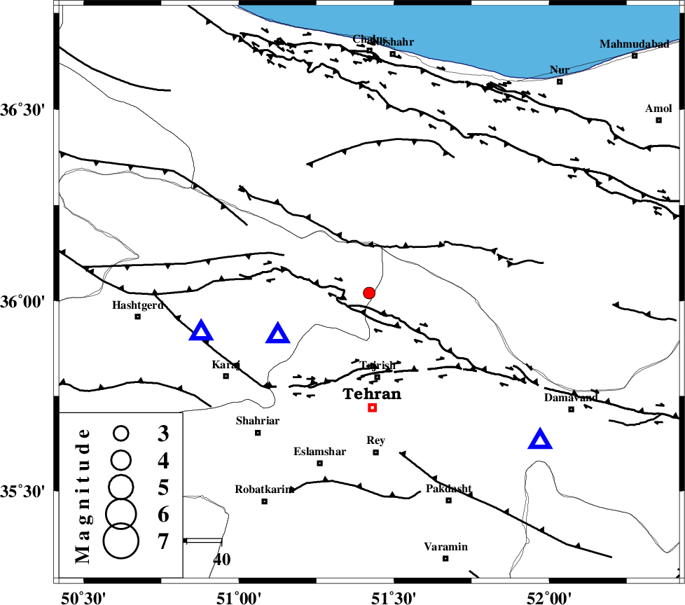
| Location | Lat:36.02 Lon: 51.42 |
| Region | Tehran Province, 25 km North of Tajrish |
Nearest Cities |
|
| 7 km North of Asara, Tehran Province | |
| 7 km of Nesa, Tehran Province | |
| 10 km North of Meygon, Tehran Province | |
| 13 km North West of Fasham, Tehran Province | |
| 18 km North of Emamzadeh davood, Tehran Province | |
| Depth | 18 km |
| Agency | |
Faults within 150 km: |
|
| MOSHA_F (Length: 234 km) , Distance to epicenter: 5 km | |
| KANDOVAN_F (Length: 90 km) , Distance to epicenter: 14 km | |
| TALEGHAN_F (Length: 71 km) , Distance to epicenter: 22 km | |
| Number of Phases | 5 |
| RMS | 0.1 |
| Number of Stations | 4 |
| Error in Latitude | >3 km |
| Error in Longitude | 3.6 km |
| Error in Depth | 8.5 km |
Download waveform in seisan format
to download seisan software Click here
to access information about IIEES stations Click here
Amplitude | ||||||||
| UID | Agency | Station | Component | Amplitude | Period | Arrival Time | Proccessing Time | Signal Clip |
| 89852 | IIEES | CHTH | N | 747.2 | 0.2 | 2013-07-09 11:16:04 | 2013-07-09 04:33:00 | n |
| 89853 | IIEES | CHTH | E | 596.5 | 0.08 | 2013-07-09 11:16:04 | 2013-07-09 04:33:00 | n |
| 89854 | IIEES | THKV | E | 286.8 | 0.28 | 2013-07-09 11:16:10 | 2013-07-09 04:33:00 | n |
| 89855 | IIEES | DAMV | E | 131 | 0.28 | 2013-07-09 11:16:13 | 2013-07-09 04:33:00 | n |
Phase | ||||||||||||
| Agency | Station | Component | Phase Type | Phase Quality | First Motion | Observed Arrival Time | Time Residual | Loc. Flag | Input Weight | Distance | Azimuth | |
| IIEES | CHTH | Z | Pg | E | 2013-07-09 11:15:59 | 0.07 | y | 29.5 | 245 | |||
| IIEES | CHTH | N | Sg | E | 2013-07-09 11:16:04 | -0.04 | y | 29.5 | 245 | |||
| IIEES | DAMV | Z | Pg | E | 2013-07-09 11:16:05 | 0 | y | 65.8 | 131 | |||
| IIEES | GHVR | Z | Pg | E | 2013-07-09 11:16:21 | -0.08 | y | 172 | 185 | |||
| IIEES | GHVR | N | Sg | E | 2013-07-09 11:16:42 | 0.04 | y | 172 | 185 | |||