
Magnitude |
3.3 |
| Date & Time (UTC) | 2013-07-09 18:32:36.1 |
| Date & Time (Local) | 1392/4/18 23:02:36.1 |
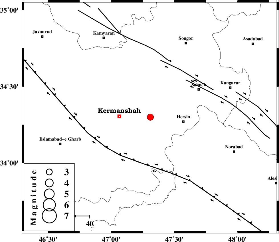
| Location | Lat:34.3 Lon: 47.31 |
| Region | Kermanshah Province, 22 km East of Kermanshah |
Nearest Cities |
|
| 13 km North of Cheshmeh kabud, Kermanshah Province | |
| 14 km North East of Kahrar-e muqufeh, Kermanshah Province | |
| 15 km West of Bisotun, Kermanshah Province | |
| 23 km East of Kermanshah, Kermanshah Province | |
| 24 km North West of Harsin, Kermanshah Province | |
| Depth | 18 km |
| Agency | |
Faults within 150 km: |
|
| HZF4 (Length: 492 km) , Distance to epicenter: 34 km | |
| SAHANEH_F (Length: 77 km) , Distance to epicenter: 37 km | |
| DINEHVAR_F (Length: 46 km) , Distance to epicenter: 41 km | |
| Number of Phases | 6 |
| RMS | 0.1 |
| Number of Stations | 5 |
| Error in Latitude | >4.7 km |
| Error in Longitude | 4.2 km |
| Error in Depth | 4.8 km |
Download waveform in seisan format
to download seisan software Click here
to access information about IIEES stations Click here
Amplitude | ||||||||
| UID | Agency | Station | Component | Amplitude | Period | Arrival Time | Proccessing Time | Signal Clip |
| 89860 | IIEES | ASAO | E | 113.3 | 0.48 | 2013-07-09 18:33:50 | 2013-07-09 07:55:00 | n |
| 89861 | IIEES | KHMZ | E | 160.8 | 0.52 | 2013-07-09 18:33:54 | 2013-07-09 07:55:00 | n |
| 89862 | IIEES | KHMZ | N | 113.7 | 0.56 | 2013-07-09 18:33:54 | 2013-07-09 07:55:00 | n |
| 89863 | IIEES | SHGR | N | 140.8 | 0.4 | 2013-07-09 18:33:55 | 2013-07-09 07:55:00 | n |
| 89864 | IIEES | SHGR | E | 199.9 | 0.4 | 2013-07-09 18:34:02 | 2013-07-09 07:55:00 | n |
Phase | ||||||||||||
| Agency | Station | Component | Phase Type | Phase Quality | First Motion | Observed Arrival Time | Time Residual | Loc. Flag | Input Weight | Distance | Azimuth | |
| IIEES | SNGE | Z | Pg | E | 2013-07-09 18:32:51 | 0.07 | y | 87.8 | 3 | |||
| IIEES | ASAO | Z | Pn | E | 2013-07-09 18:33:14 | 0.05 | y | 252 | 83 | |||
| IIEES | ASAO | E | Sg | E | 2013-07-09 18:33:47 | -0.08 | y | 252 | 83 | |||
| IIEES | KHMZ | Z | Pn | E | 2013-07-09 18:33:15 | -0.04 | y | 253 | 104 | |||
| IIEES | KHMZ | E | Sg | E | 2013-07-09 18:33:47 | 0.14 | y | 253 | 104 | |||
| IIEES | GHVR | Z | Pn | E | 2013-07-09 18:33:28 | -0.16 | y | 363 | 86 | |||