
Magnitude |
2.7 |
| Date & Time (UTC) | 2013-07-18 14:12:13.1 |
| Date & Time (Local) | 1392/4/27 18:42:13.1 |
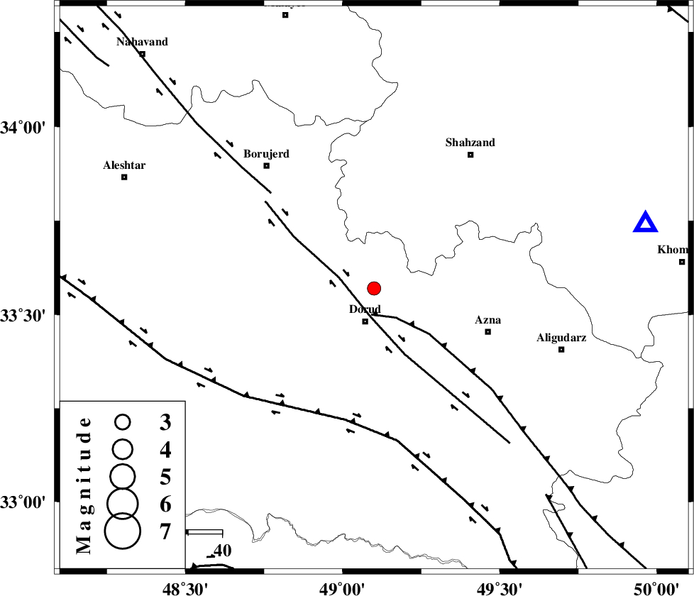
| Location | Lat:33.57 Lon: 49.1 |
| Region | Lorestan Province, 11 km Dorud |
Nearest Cities |
|
| 4 km North of Zhan, Lorestan Province | |
| 10 km North of Dorud, Lorestan Province | |
| 12 km North East of Void, Lorestan Province | |
| 14 km East of Kagheh, Lorestan Province | |
| 15 km North of Heshmatabad, Lorestan Province | |
| Depth | 12 km |
| Agency | |
Faults within 150 km: |
|
| MAIN_ZAGROS_R_F (Length: 1106 km) , Distance to epicenter: 8 km | |
| DORUD (Length: 100 km) , Distance to epicenter: 8 km | |
| HZF4 (Length: 492 km) , Distance to epicenter: 40 km | |
| Number of Phases | 5 |
| RMS | 0 |
| Number of Stations | 4 |
| Error in Latitude | >1.7 km |
| Error in Longitude | 5.1 km |
| Error in Depth | 9.6 km |
Download waveform in seisan format
to download seisan software Click here
to access information about IIEES stations Click here
Amplitude | ||||||||
| UID | Agency | Station | Component | Amplitude | Period | Arrival Time | Proccessing Time | Signal Clip |
| 89931 | IIEES | ASAO | E | 83.8 | 0.44 | 2013-07-18 14:13:04 | 2013-07-18 03:39:00 | n |
| 89932 | IIEES | SHGR | N | 184 | 0.44 | 2013-07-18 14:13:09 | 2013-07-18 03:39:00 | n |
| 89933 | IIEES | SHGR | E | 92.7 | 0.64 | 2013-07-18 14:13:17 | 2013-07-18 03:39:00 | n |
Phase | ||||||||||||
| Agency | Station | Component | Phase Type | Phase Quality | First Motion | Observed Arrival Time | Time Residual | Loc. Flag | Input Weight | Distance | Azimuth | |
| IIEES | KHMZ | Z | Pg | E | 2013-07-18 14:12:27 | 0 | y | 82.4 | 77 | |||
| IIEES | KHMZ | N | Sg | E | 2013-07-18 14:12:38 | 0.01 | y | 82.4 | 77 | |||
| IIEES | ASAO | E | Sg | E | 2013-07-18 14:12:54 | -0.01 | y | 138 | 38 | |||
| IIEES | SHGR | Z | Pn | E | 2013-07-18 14:12:41 | -0.01 | y | 165 | 190 | |||
| IIEES | SNGE | Z | Pn | E | 2013-07-18 14:12:50 | 0.01 | y | 233 | 317 | |||