
Magnitude |
2.3 |
| Date & Time (UTC) | 2013-07-23 01:05:12.2 |
| Date & Time (Local) | 1392/5/1 05:35:12.2 |
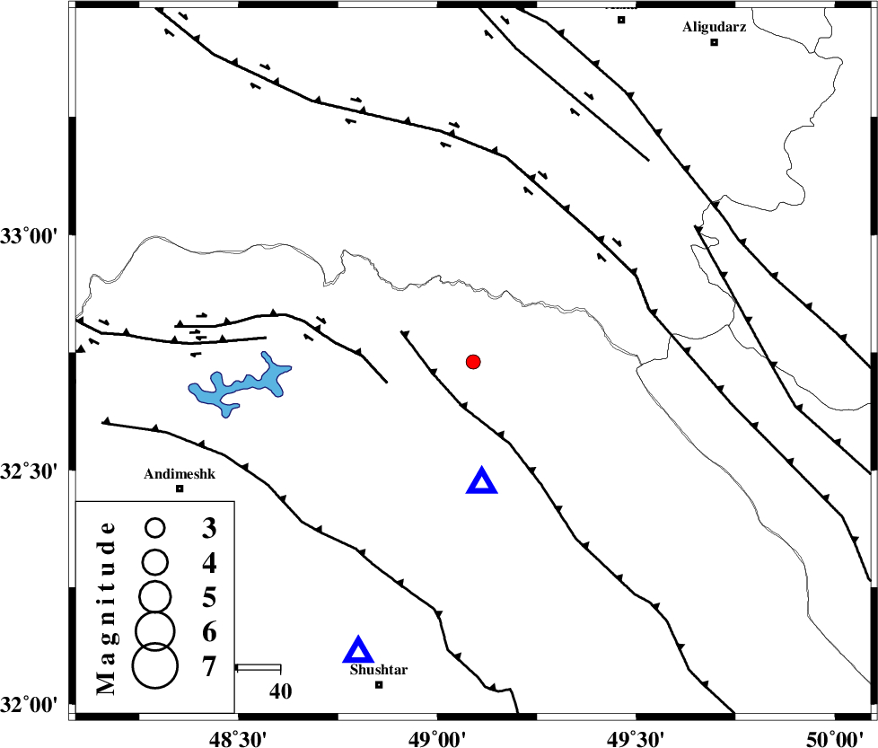
| Location | Lat:32.73 Lon: 49.09 |
| Region | Khoozestan Province, 38 km North of Lali |
Nearest Cities |
|
| 27 km East of Shuy, Khoozestan Province | |
| 35 km North East of Sardasht, Khoozestan Province | |
| 38 km North of Lali, Khoozestan Province | |
| 38 km South East of Bargsar, Lorestan Province | |
| 41 km South West of Parchal, Lorestan Province | |
| Depth | 14 km |
| Agency | |
Faults within 150 km: |
|
| MFF2 (Length: 205 km) , Distance to epicenter: 10 km | |
| BALARUD_F_Z2 (Length: 58 km) , Distance to epicenter: 21 km | |
| HZF4 (Length: 492 km) , Distance to epicenter: 41 km | |
| Number of Phases | 4 |
| RMS | 0 |
| Number of Stations | 3 |
| Error in Latitude | >6.1 km |
| Error in Longitude | 9.6 km |
| Error in Depth | 6 km |
Download waveform in seisan format
to download seisan software Click here
to access information about IIEES stations Click here
Amplitude | ||||||||
| UID | Agency | Station | Component | Amplitude | Period | Arrival Time | Proccessing Time | Signal Clip |
| 89966 | IIEES | SHGR | E | 176.7 | 0.56 | 2013-07-23 01:05:51 | 2013-07-23 02:29:00 | n |
| 89967 | IIEES | ASAO | E | 24.2 | 0.52 | 2013-07-23 01:06:19 | 2013-07-23 02:29:00 | n |
| 89968 | IIEES | GHVR | E | 14.1 | 0.44 | 2013-07-23 01:06:34 | 2013-07-23 02:29:00 | n |
| 89969 | IIEES | GHVR | N | 12.7 | 0.68 | 2013-07-23 01:06:34 | 2013-07-23 02:29:00 | n |
Phase | ||||||||||||
| Agency | Station | Component | Phase Type | Phase Quality | First Motion | Observed Arrival Time | Time Residual | Loc. Flag | Input Weight | Distance | Azimuth | |
| IIEES | SHGR | Z | Pg | E | 2013-07-23 01:05:25 | -0.01 | y | 74.2 | 202 | |||
| IIEES | ASAO | Z | Pn | E | 2013-07-23 01:05:47 | -0.01 | y | 219 | 23 | |||
| IIEES | GHVR | Z | Pn | E | 2013-07-23 01:05:54 | 0.04 | y | 279 | 45 | |||
| IIEES | GHVR | E | Sg | E | 2013-07-23 01:06:30 | -0.02 | y | 279 | 45 | |||