
Magnitude |
4.3 |
| Date & Time (UTC) | 2013-07-24 16:51:55.2 |
| Date & Time (Local) | 1392/5/2 21:21:55.2 |
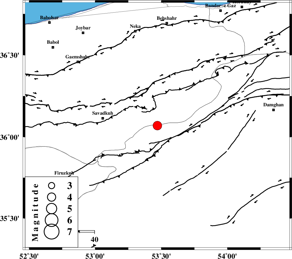
| Location | Lat:36.07 Lon: 53.47 |
| Region | Semnan Province, 38 km East of Pol-E-Sefid |
Nearest Cities |
|
| 19 km South of Kiasar, Mazandaran Province | |
| 22 km North East of Sangdeh, Mazandaran Province | |
| 26 km South West of Talma darreh, Mazandaran Province | |
| 27 km North East of Chashem, Semnan Province | |
| 30 km South East of Khalkhil, Mazandaran Province | |
| Depth | 18 km |
| Agency | |
Faults within 150 km: |
|
| N_ALBORZ_F (Length: 360 km) , Distance to epicenter: 26 km | |
| DAMGHAN_F (Length: 95 km) , Distance to epicenter: 34 km | |
| ATARI_F (Length: 185 km) , Distance to epicenter: 36 km | |
| Number of Phases | 7 |
| RMS | 0.1 |
| Number of Stations | 6 |
| Error in Latitude | >2.8 km |
| Error in Longitude | 2.7 km |
| Error in Depth | 5.4 km |
Download waveform in seisan format
to download seisan software Click here
to access information about IIEES stations Click here
Amplitude | ||||||||
| UID | Agency | Station | Component | Amplitude | Period | Arrival Time | Proccessing Time | Signal Clip |
| 89993 | IIEES | THKV | N | 2422.7 | 0.48 | 2013-07-24 16:53:09 | 2013-07-24 06:19:00 | n |
| 89994 | IIEES | THKV | E | 1616.9 | 0.44 | 2013-07-24 16:53:14 | 2013-07-24 06:19:00 | n |
| 89995 | IIEES | GHVR | N | 1674.3 | 0.44 | 2013-07-24 16:53:17 | 2013-07-24 06:19:00 | n |
Phase | ||||||||||||
| Agency | Station | Component | Phase Type | Phase Quality | First Motion | Observed Arrival Time | Time Residual | Loc. Flag | Input Weight | Distance | Azimuth | |
| IIEES | CHTH | Z | Pn | E | 2013-07-24 16:52:29 | -0.08 | y | 212 | 266 | |||
| IIEES | THKV | Z | Pn | E | 2013-07-24 16:52:31 | -0.06 | y | 234 | 267 | |||
| IIEES | GHVR | Z | Pn | E | 2013-07-24 16:52:36 | 0.18 | y | 269 | 230 | |||
| IIEES | GHVR | N | Sg | E | 2013-07-24 16:53:10 | 0.04 | y | 269 | 230 | |||
| IIEES | MRVT | Z | P | E | 2013-07-24 16:52:38 | 0.05 | y | 293 | 52 | |||
| IIEES | ASAO | Z | Pn | E | 2013-07-24 16:52:46 | 0.02 | y | 356 | 243 | |||
| IIEES | NASN | Z | P | E | 2013-07-24 16:52:48 | -0.16 | y | 368 | 190 | |||