
Magnitude |
3.2 |
| Date & Time (UTC) | 2013-07-25 03:26:23.8 |
| Date & Time (Local) | 1392/5/3 07:56:23.8 |
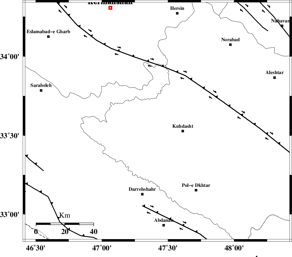
| Location | Lat:33.59 Lon: 47.42 |
| Region | Lorestan Province, 19 km West of Kuhdasht |
Nearest Cities |
|
| 13 km North of Ashtarheh golgol, Lorestan Province | |
| 19 km North West of Kuhdasht, Lorestan Province | |
| 21 km North East of Garab, Lorestan Province | |
| 22 km North of Kunani, Lorestan Province | |
| 29 km North of Suri, Lorestan Province | |
| Depth | 15 km |
| Agency | |
Faults within 150 km: |
|
| HZF4 (Length: 492 km) , Distance to epicenter: 38 km | |
| BALARUD_F_Z1 (Length: 87 km) , Distance to epicenter: 61 km | |
| MFF7 (Length: 99 km) , Distance to epicenter: 87 km | |
| Number of Phases | 5 |
| RMS | 0.1 |
| Number of Stations | 4 |
| Error in Latitude | >13.3 km |
| Error in Longitude | 8.1 km |
| Error in Depth | 9.3 km |
Download waveform in seisan format
to download seisan software Click here
to access information about IIEES stations Click here
Amplitude | ||||||||
| UID | Agency | Station | Component | Amplitude | Period | Arrival Time | Proccessing Time | Signal Clip |
| 89996 | IIEES | KHMZ | E | 193.2 | 0.44 | 2013-07-25 03:27:39 | 2013-07-25 07:11:00 | n |
| 89997 | IIEES | KHMZ | N | 117.9 | 0.76 | 2013-07-25 03:27:41 | 2013-07-25 07:11:00 | n |
Phase | ||||||||||||
| Agency | Station | Component | Phase Type | Phase Quality | First Motion | Observed Arrival Time | Time Residual | Loc. Flag | Input Weight | Distance | Azimuth | |
| IIEES | SNGE | Z | Pg | E | 2013-07-25 03:26:51 | 0 | y | 167 | 358 | |||
| IIEES | KHMZ | Z | Pn | E | 2013-07-25 03:27:01 | 0.04 | y | 237 | 85 | |||
| IIEES | KHMZ | N | Sg | E | 2013-07-25 03:27:31 | 0 | y | 237 | 85 | |||
| IIEES | ASAO | Z | Pn | E | 2013-07-25 03:27:04 | 0.06 | y | 263 | 65 | |||
| IIEES | GHVR | Z | Pn | E | 2013-07-25 03:27:16 | -0.12 | y | 367 | 73 | |||