
Magnitude |
2.7 |
| Date & Time (UTC) | 2013-07-27 18:37:07.8 |
| Date & Time (Local) | 1392/5/5 23:07:07.8 |
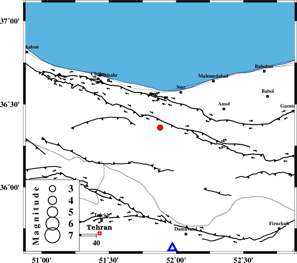
| Location | Lat:36.36 Lon: 51.88 |
| Region | Mazandaran Province, 27 km South-West of Nur |
Nearest Cities |
|
| 15 km East of Kujur, Mazandaran Province | |
| 19 km South of Narenj bon, Mazandaran Province | |
| 19 km North of Baladeh, Mazandaran Province | |
| 24 km North West of Pil, Mazandaran Province | |
| 25 km South West of Chamestan, Mazandaran Province | |
| Depth | 18 km |
| Agency | |
Faults within 150 km: |
|
| N_ALBORZ_F (Length: 360 km) , Distance to epicenter: 5 km | |
| KOJOOR (Length: 75 km) , Distance to epicenter: 17 km | |
| KHAZAR_F (Length: 523 km) , Distance to epicenter: 18 km | |
| Number of Phases | 5 |
| RMS | 0.1 |
| Number of Stations | 4 |
| Error in Latitude | >2.2 km |
| Error in Longitude | 4.8 km |
| Error in Depth | 6 km |
Download waveform in seisan format
to download seisan software Click here
to access information about IIEES stations Click here
Amplitude | ||||||||
| UID | Agency | Station | Component | Amplitude | Period | Arrival Time | Proccessing Time | Signal Clip |
| 90012 | IIEES | THKV | E | 212.4 | 0.52 | 2013-07-27 18:37:39 | 2013-07-27 08:13:00 | n |
| 90013 | IIEES | THKV | N | 219.8 | 0.48 | 2013-07-27 18:37:40 | 2013-07-27 08:13:00 | n |
Phase | ||||||||||||
| Agency | Station | Component | Phase Type | Phase Quality | First Motion | Observed Arrival Time | Time Residual | Loc. Flag | Input Weight | Distance | Azimuth | |
| IIEES | CHTH | Z | Pg | E | 2013-07-27 18:37:22 | -0.08 | y | 84.3 | 234 | |||
| IIEES | THKV | E | Sg | E | 2013-07-27 18:37:38 | -0.1 | y | 103 | 242 | |||
| IIEES | GHVR | Z | Pn | E | 2013-07-27 18:37:42 | -0.06 | y | 216 | 196 | |||
| IIEES | GHVR | E | Sg | E | 2013-07-27 18:38:09 | 0.1 | y | 216 | 196 | |||
| IIEES | ZNJK | Z | Pg | E | 2013-07-27 18:37:54 | 0.14 | y | 288 | 278 | |||