
Magnitude |
2.5 |
| Date & Time (UTC) | 2013-07-28 13:08:21.3 |
| Date & Time (Local) | 1392/5/6 17:38:21.3 |
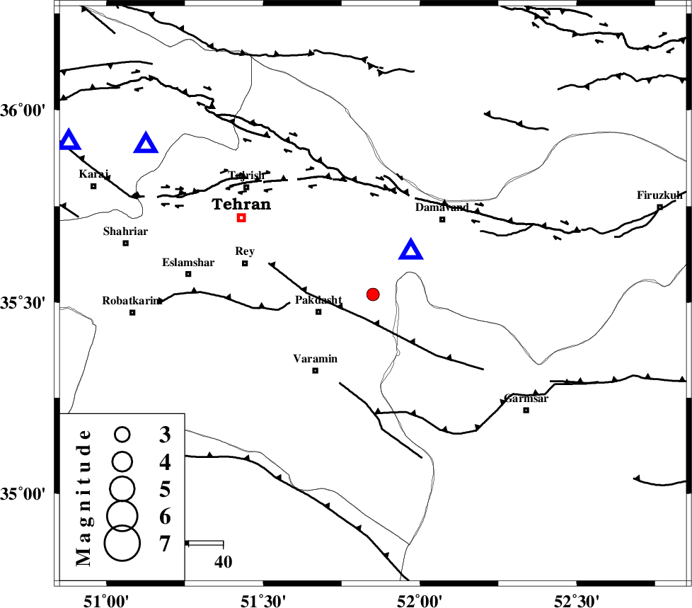
| Location | Lat:35.52 Lon: 51.85 |
| Region | Tehran Province, 16 km East of Pakdasht |
Nearest Cities |
|
| 17 km North East of Pakdasht, Tehran Province | |
| 21 km South West of Ab sard, Tehran Province | |
| 21 km North of Khalilabad, Tehran Province | |
| 24 km South of Rudehen, Tehran Province | |
| 25 km South of Bumehen, Tehran Province | |
| Depth | 42 km |
| Agency | |
Faults within 150 km: |
|
| EYVANEKEY_F (Length: 74 km) , Distance to epicenter: 7 km | |
| KAHRIZAK_F (Length: 44 km) , Distance to epicenter: 24 km | |
| PISHAV_F (Length: 34 km) , Distance to epicenter: 27 km | |
| Number of Phases | 5 |
| RMS | 0.1 |
| Number of Stations | 4 |
| Error in Latitude | >1.5 km |
| Error in Longitude | 3.7 km |
| Error in Depth | 2.7 km |
Download waveform in seisan format
to download seisan software Click here
to access information about IIEES stations Click here
Amplitude | ||||||||
| UID | Agency | Station | Component | Amplitude | Period | Arrival Time | Proccessing Time | Signal Clip |
| 90024 | IIEES | THKV | E | 128 | 0.36 | 2013-07-28 13:08:52 | 2013-07-28 03:02:00 | n |
| 90025 | IIEES | GHVR | E | 74.4 | 0.12 | 2013-07-28 13:08:59 | 2013-07-28 03:02:00 | n |
| 90026 | IIEES | GHVR | N | 98.4 | 0.36 | 2013-07-28 13:09:04 | 2013-07-28 03:02:00 | n |
Phase | ||||||||||||
| Agency | Station | Component | Phase Type | Phase Quality | First Motion | Observed Arrival Time | Time Residual | Loc. Flag | Input Weight | Distance | Azimuth | |
| IIEES | CHTH | Z | Pg | E | 2013-07-28 13:08:35 | 0.03 | y | 78.2 | 303 | |||
| IIEES | GHVR | Z | Pg | E | 2013-07-28 13:08:42 | -0.1 | y | 128 | 206 | |||
| IIEES | GHVR | N | Sg | E | 2013-07-28 13:08:58 | 0.09 | y | 128 | 206 | |||
| IIEES | ASAO | Z | Pn | E | 2013-07-28 13:08:51 | 0.03 | y | 198 | 238 | |||
| IIEES | ASAO | E | Sg | E | 2013-07-28 13:09:17 | -0.04 | y | 198 | 238 | |||