
Magnitude |
3 |
| Date & Time (UTC) | 2013-07-29 06:14:13.6 |
| Date & Time (Local) | 1392/5/7 10:44:13.6 |
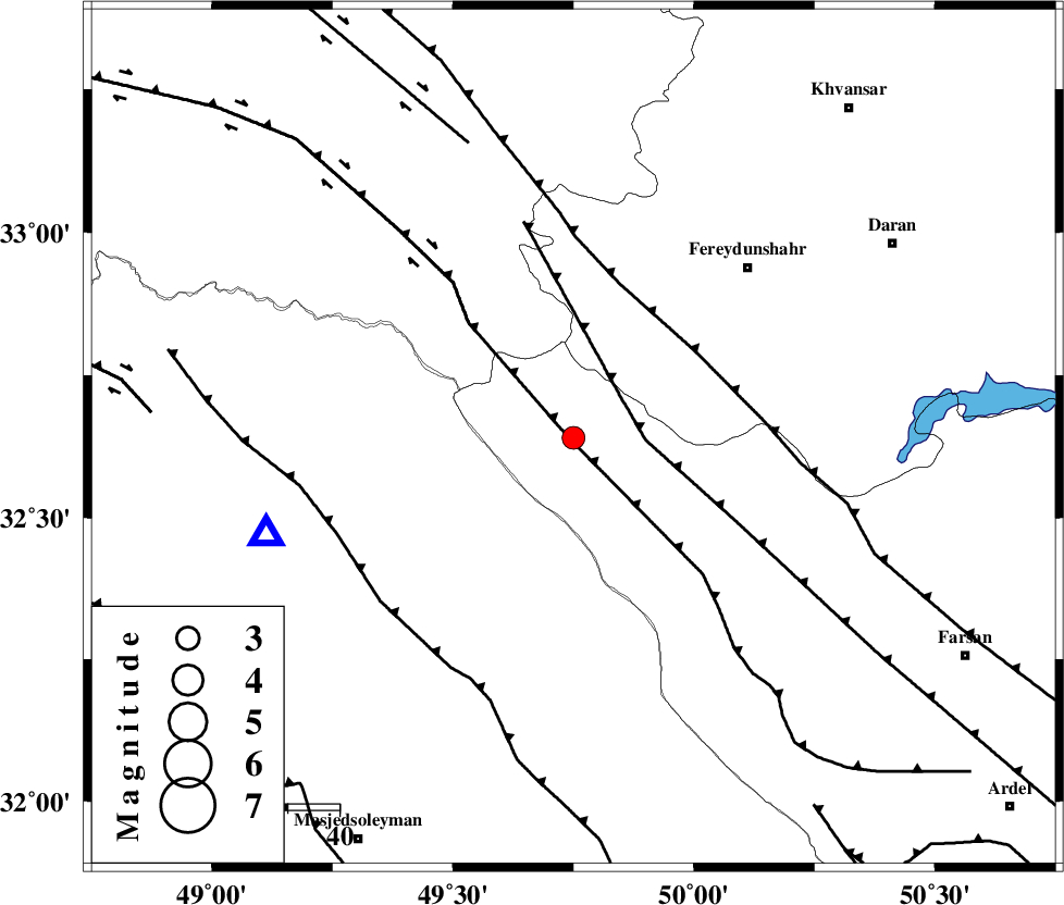
| Location | Lat:32.64 Lon: 49.75 |
| Region | Chaharmahal Bakhtiari Province, 40 km North-West of Chelgard |
Nearest Cities |
|
| 12 km West of Durak, Chaharmahal Bakhtiari Province | |
| 25 km South West of Masir, Esfahan Province | |
| 39 km South East of Parchal, Lorestan Province | |
| 40 km North West of Chelgard, Chaharmahal Bakhtiari Province | |
| 40 km South West of Sibak, Esfahan Province | |
| Depth | 14 km |
| Agency | |
Faults within 150 km: |
|
| ZARDKUH_F (Length: 139 km) , Distance to epicenter: 1 km | |
| ARDAL_F (Length: 170 km) , Distance to epicenter: 12 km | |
| MAIN_ZAGROS_R_F (Length: 1106 km) , Distance to epicenter: 29 km | |
| Number of Phases | 7 |
| RMS | 0.2 |
| Number of Stations | 5 |
| Error in Latitude | >7 km |
| Error in Longitude | 7.7 km |
| Error in Depth | 9.9 km |
Download waveform in seisan format
to download seisan software Click here
to access information about IIEES stations Click here
Amplitude | ||||||||
| UID | Agency | Station | Component | Amplitude | Period | Arrival Time | Proccessing Time | Signal Clip |
| 90030 | IIEES | ASAO | E | 131.3 | 0.56 | 2013-07-29 06:15:24 | 2013-07-29 07:50:00 | n |
Phase | ||||||||||||
| Agency | Station | Component | Phase Type | Phase Quality | First Motion | Observed Arrival Time | Time Residual | Loc. Flag | Input Weight | Distance | Azimuth | |
| IIEES | KHMZ | Z | Pg | E | 2013-07-29 06:14:34 | -0.39 | y | 124 | 9 | |||
| IIEES | KHMZ | E | Sg | E | 2013-07-29 06:14:49 | -0.02 | y | 124 | 9 | |||
| IIEES | ASAO | Z | Pn | E | 2013-07-29 06:14:47 | -0.04 | y | 214 | 7 | |||
| IIEES | ASAO | E | Sg | E | 2013-07-29 06:15:14 | 0.17 | y | 214 | 7 | |||
| IIEES | GHVR | Z | Pn | E | 2013-07-29 06:14:52 | 0.35 | y | 247 | 34 | |||
| IIEES | SNGE | Z | Pn | E | 2013-07-29 06:15:05 | 0.17 | y | 352 | 321 | |||
| IIEES | THKV | Z | Pn | E | 2013-07-29 06:15:08 | -0.27 | y | 379 | 16 | |||