
Magnitude |
2.6 |
| Date & Time (UTC) | 2013-08-01 15:59:30.6 |
| Date & Time (Local) | 1392/5/10 20:29:30.6 |
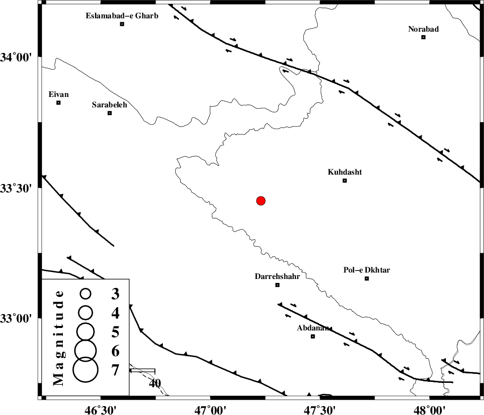
| Location | Lat:33.45 Lon: 47.23 |
| Region | Lorestan Province, 36 km North of Darreh Shahr |
Nearest Cities |
|
| 3 km of Garab, Lorestan Province | |
| 11 km North West of Kunani, Lorestan Province | |
| 24 km North West of Suri, Lorestan Province | |
| 24 km West of Ashtarheh golgol, Lorestan Province | |
| 29 km North West of Chaqabol, Lorestan Province | |
| Depth | 14 km |
| Agency | |
Faults within 150 km: |
|
| BALARUD_F_Z1 (Length: 87 km) , Distance to epicenter: 45 km | |
| HZF4 (Length: 492 km) , Distance to epicenter: 58 km | |
| MFF7 (Length: 99 km) , Distance to epicenter: 65 km | |
| Number of Phases | 5 |
| RMS | 0.2 |
| Number of Stations | 3 |
| Error in Latitude | >6.6 km |
| Error in Longitude | 6.2 km |
| Error in Depth | 9 km |
Download waveform in seisan format
to download seisan software Click here
to access information about IIEES stations Click here
Amplitude | ||||||||
| UID | Agency | Station | Component | Amplitude | Period | Arrival Time | Proccessing Time | Signal Clip |
| 90075 | IIEES | SNGE | N | 68.8 | 0.52 | 2013-08-01 16:00:32 | 2013-08-01 05:22:00 | n |
| 90076 | IIEES | SNGE | E | 65.9 | 0.56 | 2013-08-01 16:00:38 | 2013-08-01 05:22:00 | n |
| 90077 | IIEES | KHMZ | N | 24.6 | 0.48 | 2013-08-01 16:00:54 | 2013-08-01 05:22:00 | n |
Phase | ||||||||||||
| Agency | Station | Component | Phase Type | Phase Quality | First Motion | Observed Arrival Time | Time Residual | Loc. Flag | Input Weight | Distance | Azimuth | |
| IIEES | SNGE | Z | Pg | E | 2013-08-01 16:00:00 | -0.23 | y | 183 | 3 | |||
| IIEES | SNGE | N | Sg | E | 2013-08-01 16:00:23 | 0.15 | y | 183 | 3 | |||
| IIEES | KHMZ | Z | Pn | E | 2013-08-01 16:00:10 | 0.3 | y | 256 | 82 | |||
| IIEES | KHMZ | E | Sg | E | 2013-08-01 16:00:42 | -0.08 | y | 256 | 82 | |||
| IIEES | ASAO | Z | Pn | E | 2013-08-01 16:00:13 | -0.15 | y | 286 | 64 | |||