
Magnitude |
3.4 |
| Date & Time (UTC) | 2013-08-06 12:46:06.8 |
| Date & Time (Local) | 1392/5/15 17:16:06.8 |
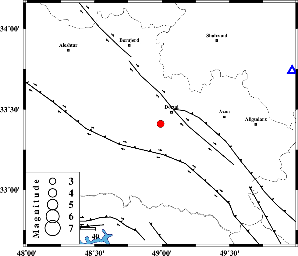
| Location | Lat:33.41 Lon: 48.99 |
| Region | Lorestan Province, 11 km Dorud |
Nearest Cities |
|
| 11 km of Dorud, Lorestan Province | |
| 13 km South of Void, Lorestan Province | |
| 16 km North of Sartang barzeh, Lorestan Province | |
| 18 km West of Heshmatabad, Lorestan Province | |
| 20 km South West of Zhan, Lorestan Province | |
| Depth | 16 km |
| Agency | |
Faults within 150 km: |
|
| DORUD (Length: 100 km) , Distance to epicenter: 13 km | |
| MAIN_ZAGROS_R_F (Length: 1106 km) , Distance to epicenter: 14 km | |
| HZF4 (Length: 492 km) , Distance to epicenter: 21 km | |
| Number of Phases | 6 |
| RMS | 0.1 |
| Number of Stations | 6 |
| Error in Latitude | >2 km |
| Error in Longitude | 2.8 km |
| Error in Depth | 3.6 km |
Download waveform in seisan format
to download seisan software Click here
to access information about IIEES stations Click here
Amplitude | ||||||||
| UID | Agency | Station | Component | Amplitude | Period | Arrival Time | Proccessing Time | Signal Clip |
| 90144 | IIEES | KHMZ | N | 1092.5 | 0.48 | 2013-08-06 12:46:42 | 2013-08-06 02:09:00 | n |
| 90145 | IIEES | SHGR | N | 872.1 | 0.28 | 2013-08-06 12:46:55 | 2013-08-06 02:09:00 | n |
| 90146 | IIEES | SHGR | E | 717 | 0.52 | 2013-08-06 12:46:56 | 2013-08-06 02:09:00 | n |
| 90147 | IIEES | ASAO | E | 465.4 | 0.52 | 2013-08-06 12:47:04 | 2013-08-06 02:09:00 | n |
Phase | ||||||||||||
| Agency | Station | Component | Phase Type | Phase Quality | First Motion | Observed Arrival Time | Time Residual | Loc. Flag | Input Weight | Distance | Azimuth | |
| IIEES | KHMZ | Z | Pg | E | 2013-08-06 12:46:23 | -0.13 | y | 97.7 | 68 | |||
| IIEES | SHGR | Z | Pg | E | 2013-08-06 12:46:30 | 0.02 | y | 146 | 187 | |||
| IIEES | ASAO | Z | Pg | E | 2013-08-06 12:46:33 | 0.12 | y | 158 | 37 | |||
| IIEES | SNGE | Z | Pn | E | 2013-08-06 12:46:44 | -0.03 | y | 240 | 321 | |||
| IIEES | GHVR | Z | Pn | E | 2013-08-06 12:46:44 | 0.1 | y | 240 | 60 | |||
| IIEES | THKV | Z | Pn | E | 2013-08-06 12:46:54 | -0.07 | y | 327 | 31 | |||