
Magnitude |
2.7 |
| Date & Time (UTC) | 2013-08-07 00:16:00.0 |
| Date & Time (Local) | 1392/5/16 04:46:00.0 |
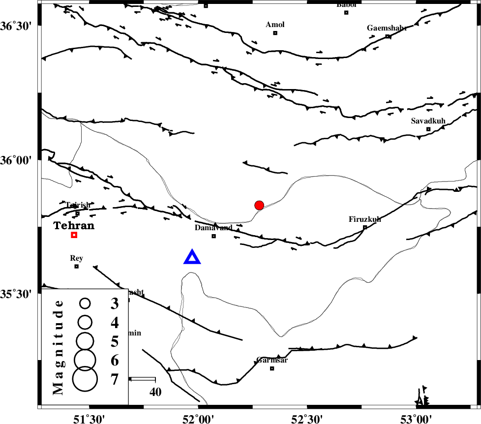
| Location | Lat:35.83 Lon: 52.28 |
| Region | Mazandaran Province, 23 km North-East of Damavand |
Nearest Cities |
|
| 11 km of Gaznak, Mazandaran Province | |
| 12 km East of Rineh, Mazandaran Province | |
| 17 km South of Baijan, Mazandaran Province | |
| 21 km North of Sarbandan, Tehran Province | |
| 22 km North West of Arjomand, Tehran Province | |
| Depth | 14 km |
| Agency | |
Faults within 150 km: |
|
| MOSHA_F (Length: 234 km) , Distance to epicenter: 12 km | |
| N_TEHRAN_F4 (Length: 115 km) , Distance to epicenter: 45 km | |
| N_ALBORZ_F (Length: 360 km) , Distance to epicenter: 46 km | |
| Number of Phases | 5 |
| RMS | 0.1 |
| Number of Stations | 4 |
| Error in Latitude | >4.8 km |
| Error in Longitude | 5.7 km |
| Error in Depth | 4.2 km |
Download waveform in seisan format
to download seisan software Click here
to access information about IIEES stations Click here
Amplitude | ||||||||
| UID | Agency | Station | Component | Amplitude | Period | Arrival Time | Proccessing Time | Signal Clip |
| 90153 | IIEES | DAMV | E | 856 | 0.12 | 2013-08-07 00:16:13 | 2013-08-07 02:09:00 | n |
| 90154 | IIEES | GHVR | N | 98.1 | 0.36 | 2013-08-07 00:16:53 | 2013-08-07 02:09:00 | n |
Phase | ||||||||||||
| Agency | Station | Component | Phase Type | Phase Quality | First Motion | Observed Arrival Time | Time Residual | Loc. Flag | Input Weight | Distance | Azimuth | |
| IIEES | DAMV | Z | Pg | E | 2013-08-07 00:16:06 | -0.07 | y | 35.9 | 231 | |||
| IIEES | CHTH | Z | Pg | E | 2013-08-07 00:16:17 | -0.07 | y | 105 | 275 | |||
| IIEES | CHTH | N | Sg | E | 2013-08-07 00:16:30 | 0.05 | y | 105 | 275 | |||
| IIEES | GHVR | Z | Pg | E | 2013-08-07 00:16:29 | 0.01 | y | 177 | 212 | |||
| IIEES | ASAO | Z | Pn | E | 2013-08-07 00:16:39 | 0.1 | y | 250 | 236 | |||