
Magnitude |
4.3 |
| Date & Time (UTC) | 2013-08-10 12:08:01.6 |
| Date & Time (Local) | 1392/5/19 16:38:01.6 |
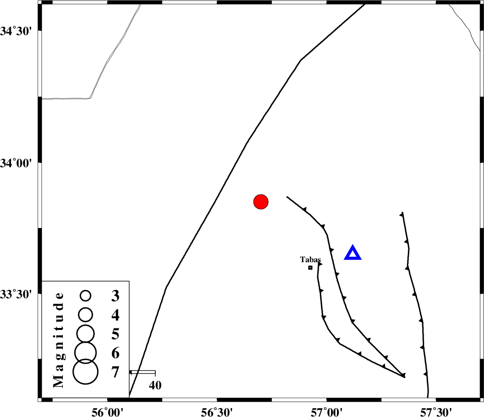
| Location | Lat:33.85 Lon: 56.7 |
| Region | Yazd Province, 34 km North-West of Tabas |
Nearest Cities |
|
| 16 km North of Jokhvah, Yazd Province | |
| 35 km North West of Tabas, Yazd Province | |
| 38 km North West of Oshtoqran, Yazd Province | |
| 40 km East of Halvan, Yazd Province | |
| 49 km North West of Kerit, Yazd Province | |
| Depth | 13 km |
| Agency | |
Faults within 150 km: |
|
| TABAS_F1 (Length: 91 km) , Distance to epicenter: 11 km | |
| NAINI_F (Length: 342 km) , Distance to epicenter: 19 km | |
| TABAS_F2 (Length: 67 km) , Distance to epicenter: 35 km | |
| Number of Phases | 6 |
| RMS | 0.1 |
| Number of Stations | 6 |
| Error in Latitude | >4.4 km |
| Error in Longitude | 1.9 km |
| Error in Depth | 3.3 km |
Download waveform in seisan format
to download seisan software Click here
to access information about IIEES stations Click here
Amplitude | ||||||||
| UID | Agency | Station | Component | Amplitude | Period | Arrival Time | Proccessing Time | Signal Clip |
| 90180 | IIEES | TABS | E | 16877.5 | 0.84 | 2013-08-10 12:08:22 | 2013-08-10 01:31:00 | n |
| 90181 | IIEES | YZKH | N | 1279.9 | 0.4 | 2013-08-10 12:09:17 | 2013-08-10 01:31:00 | n |
| 90182 | IIEES | YZKH | E | 1600.1 | 0.68 | 2013-08-10 12:09:22 | 2013-08-10 01:31:00 | n |
| 90183 | IIEES | GHVR | E | 303.8 | 0.56 | 2013-08-10 12:10:35 | 2013-08-10 01:31:00 | n |
| 90184 | IIEES | GHVR | N | 405.4 | 0.72 | 2013-08-10 12:10:44 | 2013-08-10 01:31:00 | n |
Phase | ||||||||||||
| Agency | Station | Component | Phase Type | Phase Quality | First Motion | Observed Arrival Time | Time Residual | Loc. Flag | Input Weight | Distance | Azimuth | |
| IIEES | TABS | Z | Pg | E | 2013-08-10 12:08:09 | 0 | y | 44.1 | 119 | |||
| IIEES | YZKH | Z | Pn | E | 2013-08-10 12:08:41 | 0.12 | y | 255 | 231 | |||
| IIEES | BSRN | Z | Pn | E | 2013-08-10 12:08:47 | -0.12 | y | 308 | 132 | |||
| IIEES | SHRT | Z | Pn | E | 2013-08-10 12:08:50 | 0.1 | y | 333 | 93 | |||
| IIEES | NASN | Z | Pn | E | 2013-08-10 12:08:57 | -0.06 | y | 381 | 253 | |||
| IIEES | GHVR | Z | Pn | E | 2013-08-10 12:09:12 | -0.07 | y | 508 | 279 | |||