
Magnitude |
2.9 |
| Date & Time (UTC) | 2013-08-18 02:19:55.7 |
| Date & Time (Local) | 1392/5/27 06:49:55.7 |
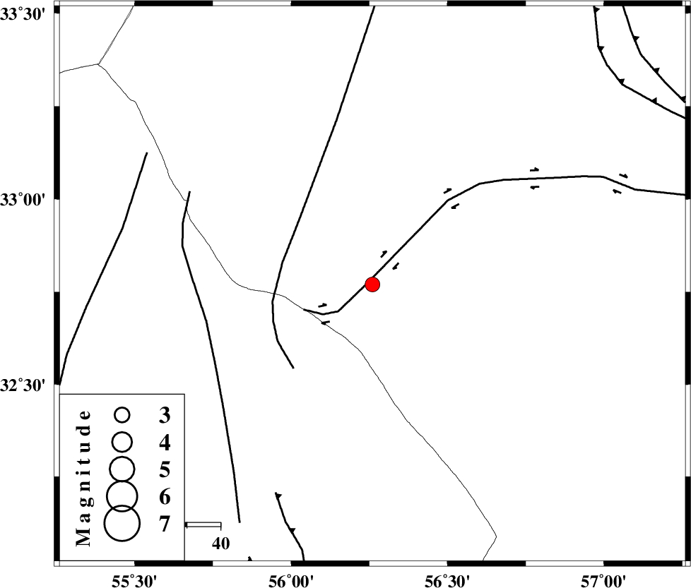
| Location | Lat:32.77 Lon: 56.26 |
| Region | Yazd Province, 111 km South-West of Tabas |
Nearest Cities |
|
| 71 km South East of Robat-e posht-e badam, Yazd Province | |
| 98 km South West of Kerit, Yazd Province | |
| 101 km South East of Darin, Yazd Province | |
| 102 km North East of Behabad, Yazd Province | |
| 106 km South West of Oshtoqran, Yazd Province | |
| Depth | 15 km |
| Agency | |
Faults within 150 km: |
|
| CHESHMEH_ROSTAM_ (Length: 142 km) , Distance to epicenter: 2 km | |
| NAINI_F (Length: 342 km) , Distance to epicenter: 28 km | |
| SARBALA_F (Length: 92 km) , Distance to epicenter: 51 km | |
| Number of Phases | 3 |
| RMS | 0 |
| Number of Stations | 4 |
| Error in Latitude | >2.6 km |
| Error in Longitude | 1.9 km |
| Error in Depth | 0 km |
Download waveform in seisan format
to download seisan software Click here
to access information about IIEES stations Click here
Amplitude | ||||||||
| UID | Agency | Station | Component | Amplitude | Period | Arrival Time | Proccessing Time | Signal Clip |
| 90261 | IIEES | TABS | N | 89.2 | 0.28 | 2013-08-18 02:20:35 | 2013-08-18 03:40:00 | n |
| 90262 | IIEES | YZKH | N | 337.8 | 0.28 | 2013-08-18 02:20:46 | 2013-08-18 03:40:00 | n |
| 90263 | IIEES | YZKH | E | 233 | 0.4 | 2013-08-18 02:20:48 | 2013-08-18 03:40:00 | n |
| 90264 | IIEES | KRBR | N | 65.4 | 0.6 | 2013-08-18 02:21:27 | 2013-08-18 03:40:00 | n |
Phase | ||||||||||||
| Agency | Station | Component | Phase Type | Phase Quality | First Motion | Observed Arrival Time | Time Residual | Loc. Flag | Input Weight | Distance | Azimuth | |
| IIEES | TABS | Z | Pg | E | 2013-08-18 02:20:16 | 0 | y | 126 | 39 | |||
| IIEES | YZKH | Z | Pg | E | 2013-08-18 02:20:22 | 0 | y | 162 | 255 | |||
| IIEES | BSRN | Z | Pn | E | 2013-08-18 02:20:38 | 0 | y | 284 | 108 | |||