
Magnitude |
2.7 |
| Date & Time (UTC) | 2013-08-20 17:14:49.9 |
| Date & Time (Local) | 1392/5/29 21:44:49.9 |
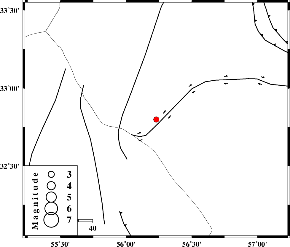
| Location | Lat:32.8 Lon: 56.23 |
| Region | Yazd Province, 110 km South-West of Tabas |
Nearest Cities |
|
| 67 km South East of Robat-e posht-e badam, Yazd Province | |
| 97 km South East of Darin, Yazd Province | |
| 97 km South West of Kerit, Yazd Province | |
| 105 km South West of Oshtoqran, Yazd Province | |
| 105 km North East of Behabad, Yazd Province | |
| Depth | 18 km |
| Agency | |
Faults within 150 km: |
|
| CHESHMEH_ROSTAM_ (Length: 142 km) , Distance to epicenter: 3 km | |
| NAINI_F (Length: 342 km) , Distance to epicenter: 24 km | |
| SARBALA_F (Length: 92 km) , Distance to epicenter: 49 km | |
| Number of Phases | 5 |
| RMS | 0.2 |
| Number of Stations | 3 |
| Error in Latitude | >2.8 km |
| Error in Longitude | 2.5 km |
| Error in Depth | 7.4 km |
Download waveform in seisan format
to download seisan software Click here
to access information about IIEES stations Click here
Amplitude | ||||||||
| UID | Agency | Station | Component | Amplitude | Period | Arrival Time | Proccessing Time | Signal Clip |
| 90302 | IIEES | YZKH | E | 101.3 | 0.4 | 2013-08-20 17:15:40 | 2013-08-20 06:42:00 | n |
| 90303 | IIEES | YZKH | N | 116 | 0.36 | 2013-08-20 17:15:41 | 2013-08-20 06:42:00 | n |
Phase | ||||||||||||
| Agency | Station | Component | Phase Type | Phase Quality | First Motion | Observed Arrival Time | Time Residual | Loc. Flag | Input Weight | Distance | Azimuth | |
| IIEES | TABS | Z | Pg | E | 2013-08-20 17:15:10 | -0.38 | y | 125 | 41 | |||
| IIEES | TABS | N | Sg | E | 2013-08-20 17:15:26 | 0.26 | y | 125 | 41 | |||
| IIEES | YZKH | Z | Pg | E | 2013-08-20 17:15:16 | 0.13 | y | 160 | 254 | |||
| IIEES | BSRN | Z | Pn | E | 2013-08-20 17:15:32 | -0.13 | y | 288 | 108 | |||
| IIEES | BSRN | N | Sg | E | 2013-08-20 17:16:11 | 0.11 | y | 288 | 108 | |||