
Magnitude |
2.7 |
| Date & Time (UTC) | 2013-08-24 04:11:40.1 |
| Date & Time (Local) | 1392/6/2 08:41:40.1 |
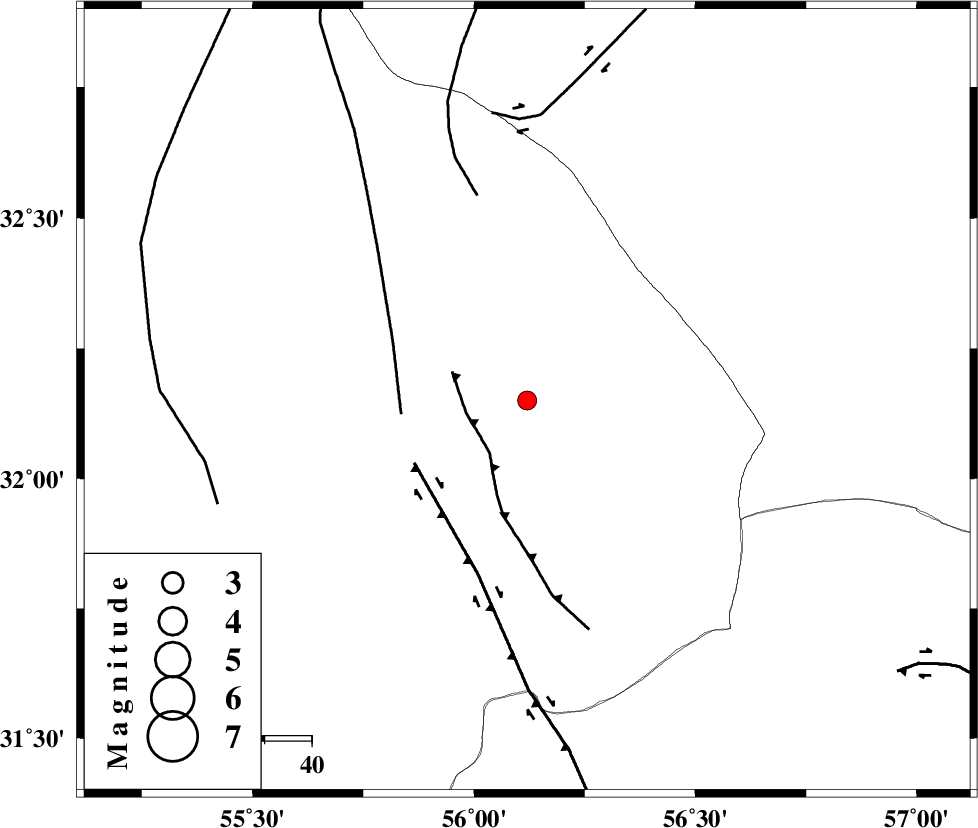
| Location | Lat:32.15 Lon: 56.12 |
| Region | Yazd Province, 91 km North-East of Bafq |
Nearest Cities |
|
| 32 km North of Behabad, Yazd Province | |
| 46 km North of Benestan, Yazd Province | |
| 54 km North West of Asfih, Yazd Province | |
| 56 km North East of Kushk, Yazd Province | |
| 76 km North East of Basab, Yazd Province | |
| Depth | 18 km |
| Agency | |
Faults within 150 km: |
|
| JAFARABAD_F (Length: 60 km) , Distance to epicenter: 12 km | |
| SARBALA_F (Length: 92 km) , Distance to epicenter: 27 km | |
| KUHBANAN_F (Length: 189 km) , Distance to epicenter: 27 km | |
| Number of Phases | 5 |
| RMS | 0 |
| Number of Stations | 4 |
| Error in Latitude | >4.6 km |
| Error in Longitude | 2.5 km |
| Error in Depth | 9.9 km |
Download waveform in seisan format
to download seisan software Click here
to access information about IIEES stations Click here
Amplitude | ||||||||
| UID | Agency | Station | Component | Amplitude | Period | Arrival Time | Proccessing Time | Signal Clip |
| 90315 | IIEES | YZKH | E | 84.5 | 0.32 | 2013-08-24 04:12:27 | 2013-08-24 06:05:00 | n |
| 90316 | IIEES | KRBR | E | 79.1 | 0.44 | 2013-08-24 04:12:52 | 2013-08-24 06:05:00 | n |
Phase | ||||||||||||
| Agency | Station | Component | Phase Type | Phase Quality | First Motion | Observed Arrival Time | Time Residual | Loc. Flag | Input Weight | Distance | Azimuth | |
| IIEES | YZKH | Z | Pg | E | 2013-08-24 04:12:04 | 0.01 | y | 146 | 281 | |||
| IIEES | YZKH | E | Sg | E | 2013-08-24 04:12:22 | -0.01 | y | 146 | 281 | |||
| IIEES | TABS | Z | Pg | E | 2013-08-24 04:12:11 | 0.01 | y | 191 | 29 | |||
| IIEES | KRBR | Z | Pn | E | 2013-08-24 04:12:18 | 0.01 | y | 247 | 166 | |||
| IIEES | BSRN | Z | Pn | E | 2013-08-24 04:12:22 | -0.02 | y | 285 | 93 | |||