
Magnitude |
2.5 |
| Date & Time (UTC) | 2013-08-31 04:41:54.5 |
| Date & Time (Local) | 1392/6/9 09:11:54.5 |
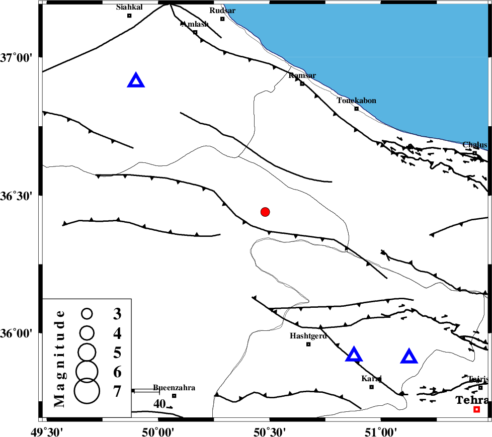
| Location | Lat:36.44 Lon: 50.48 |
| Region | Ghazvin Province, 45 km North of Abyek |
Nearest Cities |
|
| 2 km of Moallemkelayeh, Ghazvin Province | |
| 19 km North East of Rajaeedasht, Ghazvin Province | |
| 23 km South of Tamol, Mazandaran Province | |
| 33 km North West of Taleqan, Tehran Province | |
| 38 km North West of Shahrak, Tehran Province | |
| Depth | 6 km |
| Agency | |
Faults within 150 km: |
|
| ALAMUTRUD_F (Length: 140 km) , Distance to epicenter: 8 km | |
| BONAN_F (Length: 74 km) , Distance to epicenter: 19 km | |
| N_QAZVIN_F (Length: 72 km) , Distance to epicenter: 20 km | |
| Number of Phases | 6 |
| RMS | 0.1 |
| Number of Stations | 6 |
| Error in Latitude | >3 km |
| Error in Longitude | 3.1 km |
| Error in Depth | 3.1 km |
Download waveform in seisan format
to download seisan software Click here
to access information about IIEES stations Click here
Amplitude | ||||||||
| UID | Agency | Station | Component | Amplitude | Period | Arrival Time | Proccessing Time | Signal Clip |
| 90404 | IIEES | THKV | N | 294 | 0.14 | 2013-08-31 04:42:17 | 2013-08-31 06:09:00 | n |
| 90405 | IIEES | THKV | E | 337 | 0.14 | 2013-08-31 04:42:17 | 2013-08-31 06:09:00 | n |
| 90406 | IIEES | ZNJK | E | 64.6 | 0.34 | 2013-08-31 04:42:46 | 2013-08-31 06:09:00 | n |
Phase | ||||||||||||
| Agency | Station | Component | Phase Type | Phase Quality | First Motion | Observed Arrival Time | Time Residual | Loc. Flag | Input Weight | Distance | Azimuth | |
| IIEES | THKV | Z | Pg | E | 2013-08-31 04:42:06 | -0.23 | y | 68.4 | 149 | |||
| IIEES | DAMV | Z | Pg | E | 2013-08-31 04:42:22 | 0.11 | y | 162 | 123 | |||
| IIEES | ZNJK | Z | Pg | E | 2013-08-31 04:42:22 | 0.04 | y | 163 | 279 | |||
| IIEES | ASAO | Z | Pn | E | 2013-08-31 04:42:29 | -0.01 | y | 214 | 191 | |||
| IIEES | GHVR | Z | Pn | E | 2013-08-31 04:42:31 | 0.15 | y | 228 | 162 | |||
| IIEES | GRMI | Z | Pn | E | 2013-08-31 04:42:46 | -0.08 | y | 348 | 320 | |||