
Magnitude |
2.9 |
| Date & Time (UTC) | 2013-09-12 03:52:30.4 |
| Date & Time (Local) | 1392/6/21 08:22:30.4 |
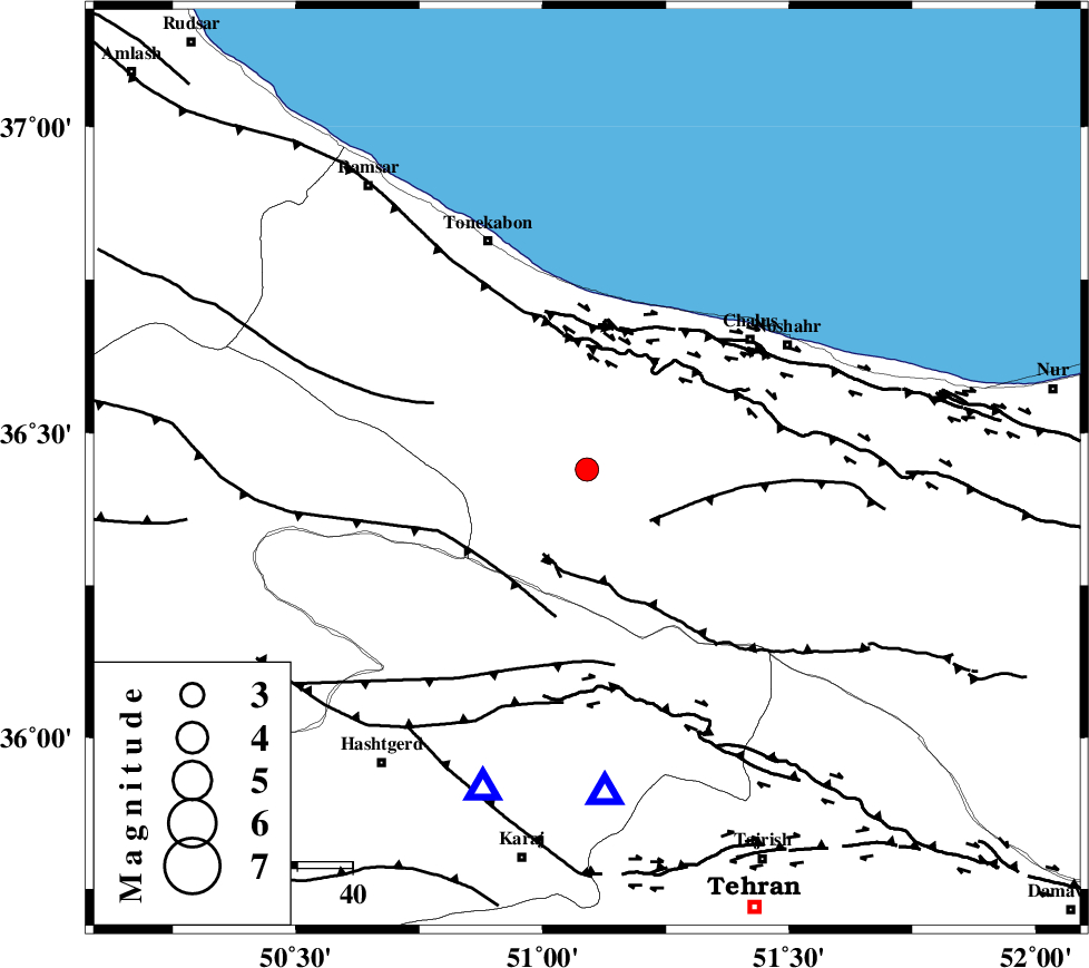
| Location | Lat:36.44 Lon: 51.09 |
| Region | Mazandaran Province, 38 km South-West of Chalus |
Nearest Cities |
|
| 16 km West of Kardichal, Mazandaran Province | |
| 16 km North West of Marzanabad, Mazandaran Province | |
| 16 km West of Goyter, Mazandaran Province | |
| 16 km North West of Tavir, Mazandaran Province | |
| 30 km South West of Kelarabad, Mazandaran Province | |
| Depth | 14 km |
| Agency | |
Faults within 150 km: |
|
| KOJOOR (Length: 75 km) , Distance to epicenter: 15 km | |
| KANDOVAN_F (Length: 90 km) , Distance to epicenter: 18 km | |
| N_ALBORZ_F (Length: 360 km) , Distance to epicenter: 21 km | |
| Number of Phases | 7 |
| RMS | 0.1 |
| Number of Stations | 5 |
| Error in Latitude | >3.1 km |
| Error in Longitude | 5.1 km |
| Error in Depth | 7.3 km |
Download waveform in seisan format
to download seisan software Click here
to access information about IIEES stations Click here
Amplitude | ||||||||
| UID | Agency | Station | Component | Amplitude | Period | Arrival Time | Proccessing Time | Signal Clip |
| 90532 | IIEES | ZNJK | N | 88.1 | 0.25 | 2013-09-12 03:53:34 | 2013-09-12 05:16:00 | n |
Phase | ||||||||||||
| Agency | Station | Component | Phase Type | Phase Quality | First Motion | Observed Arrival Time | Time Residual | Loc. Flag | Input Weight | Distance | Azimuth | |
| IIEES | ZNJK | Z | Pn | E | 2013-09-12 03:53:05 | 0.02 | y | 217 | 277 | |||
| IIEES | GHVR | Z | Pn | E | 2013-09-12 03:53:05 | -0.01 | y | 218 | 176 | |||
| IIEES | GHVR | E | Sg | E | 2013-09-12 03:53:32 | -0.09 | y | 218 | 176 | |||
| IIEES | ASAO | Z | Pn | E | 2013-09-12 03:53:07 | 0.28 | y | 231 | 205 | |||
| IIEES | ASAO | E | Sg | E | 2013-09-12 03:53:36 | -0.02 | y | 231 | 205 | |||
| IIEES | KHMZ | Z | Pn | E | 2013-09-12 03:53:17 | -0.01 | y | 317 | 199 | |||
| IIEES | GRMI | Z | Pn | E | 2013-09-12 03:53:25 | -0.22 | y | 385 | 314 | |||