
Magnitude |
3.8 |
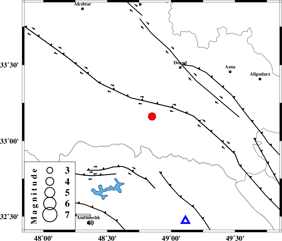
| Date & Time (UTC) | 2013-09-13 00:25:49.9 |
| Date & Time (Local) | 1392/6/22 04:55:49.9 |
| Location | Lat:33.16 Lon: 48.85 |
| Region | Lorestan Province, 41 km South-West of Dorud |
Nearest Cities |
|
| 5 km of Chamsangar, Lorestan Province | |
| 15 km North of Bargsar, Lorestan Province | |
| 16 km South West of Sartang barzeh, Lorestan Province | |
| 30 km West of Shulabad, Lorestan Province | |
| 33 km South East of Emanabad, Lorestan Province | |
| Depth | 14 km |
| Agency | |
Faults within 150 km: |
|
| HZF4 (Length: 492 km) , Distance to epicenter: 16 km | |
| MFF2 (Length: 205 km) , Distance to epicenter: 41 km | |
| DORUD (Length: 100 km) , Distance to epicenter: 41 km | |
| Number of Phases | 4 |
| RMS | 0.1 |
| Number of Stations | 5 |
| Error in Latitude | >13 km |
| Error in Longitude | 3.7 km |
| Error in Depth | 5.5 km |
Download waveform in seisan format
to download seisan software Click here
to access information about IIEES stations Click here
Amplitude | ||||||||
| UID | Agency | Station | Component | Amplitude | Period | Arrival Time | Proccessing Time | Signal Clip |
| 90539 | IIEES | KHMZ | E | 1468.4 | 0.52 | 2013-09-13 00:26:33 | 2013-09-13 02:03:00 | n |
| 90540 | IIEES | ASAO | E | 990.8 | 0.52 | 2013-09-13 00:26:50 | 2013-09-13 02:03:00 | n |
| 90541 | IIEES | GHVR | E | 670.3 | 0.68 | 2013-09-13 00:27:17 | 2013-09-13 02:03:00 | n |
| 90542 | IIEES | DAMV | E | 183.3 | 0.6 | 2013-09-13 00:27:52 | 2013-09-13 02:03:00 | n |
Phase | ||||||||||||
| Agency | Station | Component | Phase Type | Phase Quality | First Motion | Observed Arrival Time | Time Residual | Loc. Flag | Input Weight | Distance | Azimuth | |
| IIEES | KHMZ | Z | Pg | E | 2013-09-13 00:26:10 | -0.07 | y | 121 | 58 | |||
| IIEES | ASAO | Z | Pg | E | 2013-09-13 00:26:20 | 0.02 | y | 188 | 35 | |||
| IIEES | SNGE | Z | Pg | E | 2013-09-13 00:26:31 | -0.02 | y | 255 | 327 | |||
| IIEES | DAMV | Z | Pn | E | 2013-09-13 00:26:47 | 0.1 | y | 396 | 45 | |||