
Magnitude |
3.2 |
| Date & Time (UTC) | 2013-09-20 04:12:57.9 |
| Date & Time (Local) | 1392/6/29 08:42:57.9 |
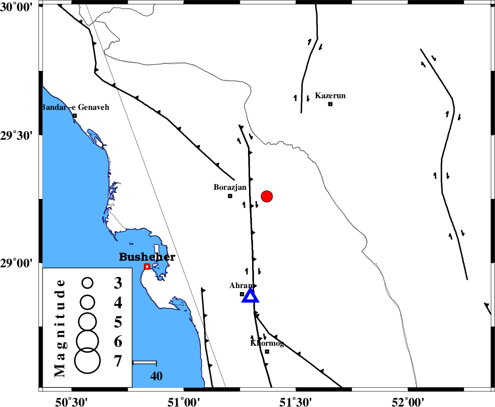
| Location | Lat:29.26 Lon: 51.37 |
| Region | Bushehr Province, 16 km East of Borazjan |
Nearest Cities |
|
| 16 km East of Borazjan, Bushehr Province | |
| 18 km North East of Sarkareh, Bushehr Province | |
| 20 km South of Dalki, Bushehr Province | |
| 22 km South East of Nazar aqa, Bushehr Province | |
| 27 km South East of Saedabad, Bushehr Province | |
| Depth | 5 km |
| Agency | |
Faults within 150 km: |
|
| BORAZJAN_F (Length: 168 km) , Distance to epicenter: 7 km | |
| ZFF3 (Length: 125 km) , Distance to epicenter: 16 km | |
| KAZERUN_F (Length: 96 km) , Distance to epicenter: 39 km | |
| Number of Phases | 6 |
| RMS | 0.1 |
| Number of Stations | 5 |
| Error in Latitude | >5 km |
| Error in Longitude | 4.2 km |
| Error in Depth | 9.1 km |
Download waveform in seisan format
to download seisan software Click here
to access information about IIEES stations Click here
Amplitude | ||||||||
| UID | Agency | Station | Component | Amplitude | Period | Arrival Time | Proccessing Time | Signal Clip |
| 90578 | IIEES | AHRM | N | 2547.6 | 0.36 | 2013-09-20 04:13:15 | 2013-09-20 06:04:00 | n |
Phase | ||||||||||||
| Agency | Station | Component | Phase Type | Phase Quality | First Motion | Observed Arrival Time | Time Residual | Loc. Flag | Input Weight | Distance | Azimuth | |
| IIEES | AHRM | Z | Pg | E | 2013-09-20 04:13:06 | 0.14 | y | 44.1 | 189 | |||
| IIEES | AHRM | N | Sg | E | 2013-09-20 04:13:12 | -0.1 | y | 44.1 | 189 | |||
| IIEES | SHGR | N | Sn | 2013-09-20 04:14:39 | 0.06 | y | 400 | 323 | ||||
| IIEES | YZKH | Z | P | E | 2013-09-20 04:14:04 | 0.09 | y | 464 | 41 | |||
| IIEES | GHVR | Z | P | E | 2013-09-20 04:14:18 | -0.28 | y | 579 | 359 | |||
| IIEES | TABS | Z | P | E | 2013-09-20 04:14:37 | 0.01 | y | 732 | 47 | |||