
Magnitude |
3.4 |
| Date & Time (UTC) | 2013-09-20 06:07:57.6 |
| Date & Time (Local) | 1392/6/29 10:37:57.6 |
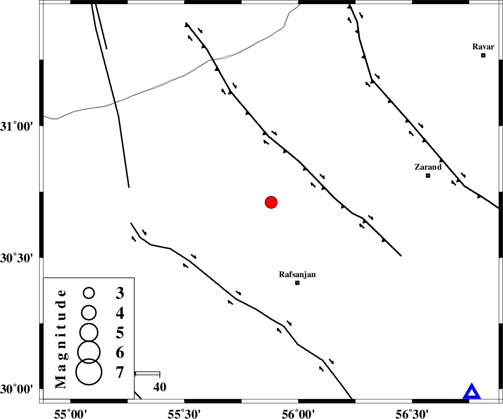
| Location | Lat:30.71 Lon: 55.88 |
| Region | Kerman Province, 35 km North-West of Rafsanjan |
Nearest Cities |
|
| 14 km South of Ferdosiyeh, Kerman Province | |
| 25 km South East of Bahreman, Kerman Province | |
| 29 km North East of Kashkuieyeh, Kerman Province | |
| 31 km South East of Esmaeelabad, Kerman Province | |
| 35 km South of Seyriz, Kerman Province | |
| Depth | 14 km |
| Agency | |
Faults within 150 km: |
|
| DARIVAN_F (Length: 131 km) , Distance to epicenter: 21 km | |
| RAFSANJAN_F (Length: 129 km) , Distance to epicenter: 42 km | |
| ANAR_F (Length: 127 km) , Distance to epicenter: 60 km | |
| Number of Phases | 5 |
| RMS | 0.1 |
| Number of Stations | 3 |
| Error in Latitude | >7.1 km |
| Error in Longitude | 2 km |
| Error in Depth | 11.4 km |
Download waveform in seisan format
to download seisan software Click here
to access information about IIEES stations Click here
Amplitude | ||||||||
| UID | Agency | Station | Component | Amplitude | Period | Arrival Time | Proccessing Time | Signal Clip |
| 90582 | IIEES | YZKH | N | 255.2 | 0.36 | 2013-09-20 06:09:02 | 2013-09-20 07:35:00 | n |
| 90583 | IIEES | YZKH | E | 285.5 | 0.4 | 2013-09-20 06:09:05 | 2013-09-20 07:35:00 | n |
Phase | ||||||||||||
| Agency | Station | Component | Phase Type | Phase Quality | First Motion | Observed Arrival Time | Time Residual | Loc. Flag | Input Weight | Distance | Azimuth | |
| IIEES | YZKH | Z | P | E | 2013-09-20 06:08:33 | 0.11 | y | 223 | 327 | |||
| IIEES | YZKH | N | Sg | E | 2013-09-20 06:09:00 | -0.07 | y | 223 | 327 | |||
| IIEES | BSRN | Z | P | E | 2013-09-20 06:08:47 | -0.05 | y | 339 | 65 | |||
| IIEES | TABS | Z | P | E | 2013-09-20 06:08:48 | -0.05 | y | 346 | 19 | |||
| IIEES | TABS | N | Sg | E | 2013-09-20 06:09:34 | 0.05 | y | 346 | 19 | |||