
Magnitude |
2.2 |
| Date & Time (UTC) | 2013-10-05 17:28:10.9 |
| Date & Time (Local) | 1392/7/13 20:58:10.9 |
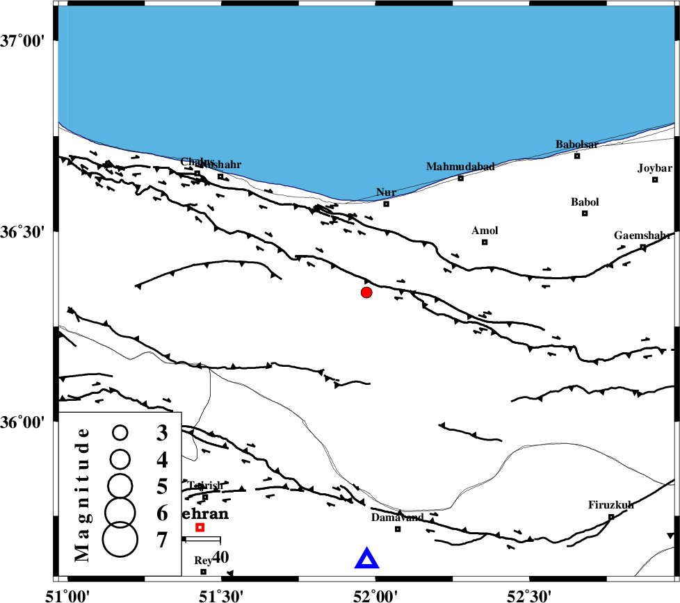
| Location | Lat:36.34 Lon: 51.97 |
| Region | Mazandaran Province, 27 km South of Nur |
Nearest Cities |
|
| 18 km North of Pil, Mazandaran Province | |
| 20 km South West of Chamestan, Mazandaran Province | |
| 22 km North East of Baladeh, Mazandaran Province | |
| 23 km East of Kujur, Mazandaran Province | |
| 23 km South East of Narenj bon, Mazandaran Province | |
| Depth | 14 km |
| Agency | |
Faults within 150 km: |
|
| N_ALBORZ_F (Length: 360 km) , Distance to epicenter: 6 km | |
| KHAZAR_F (Length: 523 km) , Distance to epicenter: 19 km | |
| KANDOVAN_F (Length: 90 km) , Distance to epicenter: 24 km | |
| Number of Phases | 4 |
| RMS | 0.1 |
| Number of Stations | 4 |
| Error in Latitude | >8.7 km |
| Error in Longitude | 4.3 km |
| Error in Depth | 6.5 km |
Download waveform in seisan format
to download seisan software Click here
to access information about IIEES stations Click here
Amplitude | ||||||||
| UID | Agency | Station | Component | Amplitude | Period | Arrival Time | Proccessing Time | Signal Clip |
| 90719 | IIEES | CHTH | N | 96.6 | 0.36 | 2013-10-05 17:28:39 | 2013-10-05 07:18:00 | n |
| 90720 | IIEES | CHTH | E | 93.2 | 0.16 | 2013-10-05 17:28:39 | 2013-10-05 07:18:00 | n |
| 90721 | IIEES | GHVR | N | 20 | 0.48 | 2013-10-05 17:29:21 | 2013-10-05 07:18:00 | n |
| 90722 | IIEES | ZNJK | N | 9.7 | 0.28 | 2013-10-05 17:29:35 | 2013-10-05 07:18:00 | n |
| 90723 | IIEES | ZNJK | E | 7.5 | 0.24 | 2013-10-05 17:29:37 | 2013-10-05 07:18:00 | n |
Phase | ||||||||||||
| Agency | Station | Component | Phase Type | Phase Quality | First Motion | Observed Arrival Time | Time Residual | Loc. Flag | Input Weight | Distance | Azimuth | |
| IIEES | CHTH | Z | Pg | E | 2013-10-05 17:28:26 | -0.17 | y | 89.8 | 238 | |||
| IIEES | CHTH | E | S | E | 2013-10-05 17:28:37 | 0.04 | y | 89.8 | 238 | |||
| IIEES | GHVR | Z | Pg | E | 2013-10-05 17:28:46 | -0.06 | y | 216 | 198 | |||
| IIEES | ASAO | Z | Pn | E | 2013-10-05 17:28:52 | 0.19 | y | 266 | 222 | |||