
Magnitude |
3.7 |
| Date & Time (UTC) | 2013-10-07 02:40:08.9 |
| Date & Time (Local) | 1392/7/15 06:10:08.9 |
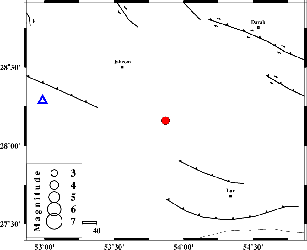
| Location | Lat:28.16 Lon: 53.87 |
| Region | Fars Province, 49 km South-East of Jahrom |
Nearest Cities |
|
| 2 km of Juyam, Fars Province | |
| 27 km North East of Balafan, Fars Province | |
| 27 km North of Kureh, Fars Province | |
| 36 km South East of Khorramabad, Fars Province | |
| 42 km South West of Dabiran, Fars Province | |
| Depth | 46 km |
| Agency | |
Faults within 150 km: |
|
| BERIZ_F (Length: 49 km) , Distance to epicenter: 30 km | |
| QIR_F (Length: 130 km) , Distance to epicenter: 49 km | |
| LAR_F (Length: 99 km) , Distance to epicenter: 56 km | |
| Number of Phases | 6 |
| RMS | 0.1 |
| Number of Stations | 7 |
| Error in Latitude | >3.6 km |
| Error in Longitude | 2.9 km |
| Error in Depth | 5.6 km |
Download waveform in seisan format
to download seisan software Click here
to access information about IIEES stations Click here
Amplitude | ||||||||
| UID | Agency | Station | Component | Amplitude | Period | Arrival Time | Proccessing Time | Signal Clip |
| 90730 | IIEES | BNDS | N | 677.9 | 0.56 | 2013-10-07 02:41:26 | 2013-10-07 04:26:00 | n |
| 90731 | IIEES | BNDS | E | 476.4 | 0.52 | 2013-10-07 02:41:28 | 2013-10-07 04:26:00 | n |
| 90732 | IIEES | AHRM | N | 271.3 | 0.6 | 2013-10-07 02:41:34 | 2013-10-07 04:26:00 | n |
| 90733 | IIEES | AHRM | E | 182.9 | 0.56 | 2013-10-07 02:41:51 | 2013-10-07 04:26:00 | n |
| 90734 | IIEES | KRBR | N | 205.3 | 0.56 | 2013-10-07 02:41:43 | 2013-10-07 04:26:00 | n |
| 90735 | IIEES | KRBR | E | 222.1 | 0.44 | 2013-10-07 02:41:49 | 2013-10-07 04:26:00 | n |
Phase | ||||||||||||
| Agency | Station | Component | Phase Type | Phase Quality | First Motion | Observed Arrival Time | Time Residual | Loc. Flag | Input Weight | Distance | Azimuth | |
| IIEES | AHRM | Z | Pn | E | 2013-10-07 02:40:45 | -0.09 | y | 264 | 288 | |||
| IIEES | AHRM | N | Sg | E | 2013-10-07 02:41:22 | 0.06 | y | 264 | 288 | |||
| IIEES | YZKH | Z | P | E | 2013-10-07 02:41:12 | 0.16 | y | 474 | 8 | |||
| IIEES | TABS | Z | Pn | E | 2013-10-07 02:41:37 | -0.14 | y | 683 | 26 | |||
| IIEES | CHBR | Z | P | E | 2013-10-07 02:41:42 | 0.08 | y | 715 | 112 | |||
| IIEES | GHVR | Z | Pn | E | 2013-10-07 02:41:45 | -0.15 | y | 744 | 341 | |||