
Magnitude |
3.8 |
| Date & Time (UTC) | 2013-10-09 02:07:17.2 |
| Date & Time (Local) | 1392/7/17 05:37:17.2 |
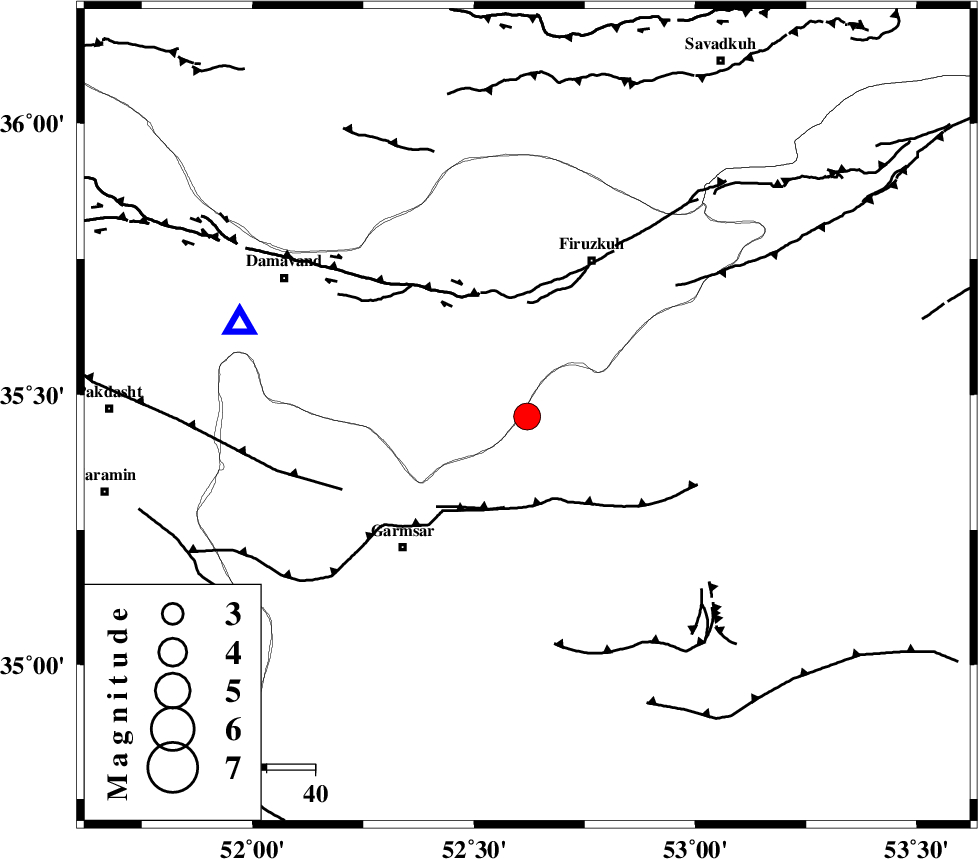
| Location | Lat:35.46 Lon: 52.62 |
| Region | Semnan Province, 35 km South-West of Firuzkuh |
Nearest Cities |
|
| 13 km South of Atashan, Tehran Province | |
| 26 km North of Aradan, Semnan Province | |
| 27 km North of Kohanabad, Semnan Province | |
| 30 km North East of Davarabad, Semnan Province | |
| 35 km South West of Firuzkuh, Tehran Province | |
| Depth | 14 km |
| Agency | |
Faults within 150 km: |
|
| GARMSAR_F (Length: 77 km) , Distance to epicenter: 19 km | |
| MOSHA_F (Length: 234 km) , Distance to epicenter: 26 km | |
| ATARI_F (Length: 185 km) , Distance to epicenter: 41 km | |
| Number of Phases | 4 |
| RMS | 0 |
| Number of Stations | 4 |
| Error in Latitude | >2.3 km |
| Error in Longitude | 7.6 km |
| Error in Depth | 5.1 km |
Download waveform in seisan format
to download seisan software Click here
to access information about IIEES stations Click here
Amplitude | ||||||||
| UID | Agency | Station | Component | Amplitude | Period | Arrival Time | Proccessing Time | Signal Clip |
| 90750 | IIEES | GHVR | N | 1778.2 | 0.4 | 2013-10-09 02:08:10 | 2013-10-09 03:32:00 | n |
| 90751 | IIEES | GHVR | E | 1883.5 | 0.44 | 2013-10-09 02:08:10 | 2013-10-09 03:32:00 | n |
| 90752 | IIEES | ASAO | E | 247.4 | 0.52 | 2013-10-09 02:08:31 | 2013-10-09 03:32:00 | n |
Phase | ||||||||||||
| Agency | Station | Component | Phase Type | Phase Quality | First Motion | Observed Arrival Time | Time Residual | Loc. Flag | Input Weight | Distance | Azimuth | |
| IIEES | CHTH | Z | Pg | E | 2013-10-09 02:07:41 | -0.03 | y | 144 | 291 | |||
| IIEES | GHVR | Z | Pg | E | 2013-10-09 02:07:44 | -0.02 | y | 166 | 229 | |||
| IIEES | GHVR | E | Sg | E | 2013-10-09 02:08:04 | 0.02 | y | 166 | 229 | |||
| IIEES | ZNJK | Z | Pn | E | 2013-10-09 02:08:12 | 0.04 | y | 379 | 292 | |||